Rust Family Foundation: Archaeology Grants Program
Integration or Evasion: The Response of Hinterland Populations to the Royal Collapse of Piedras Negras
[RFF-2016-12]
Principal Investigator: Whittaker Schroder, Department of Anthropology, University of Pennsylvania
[RFF-2016-12]
Principal Investigator: Whittaker Schroder, Department of Anthropology, University of Pennsylvania
Importance of the Project
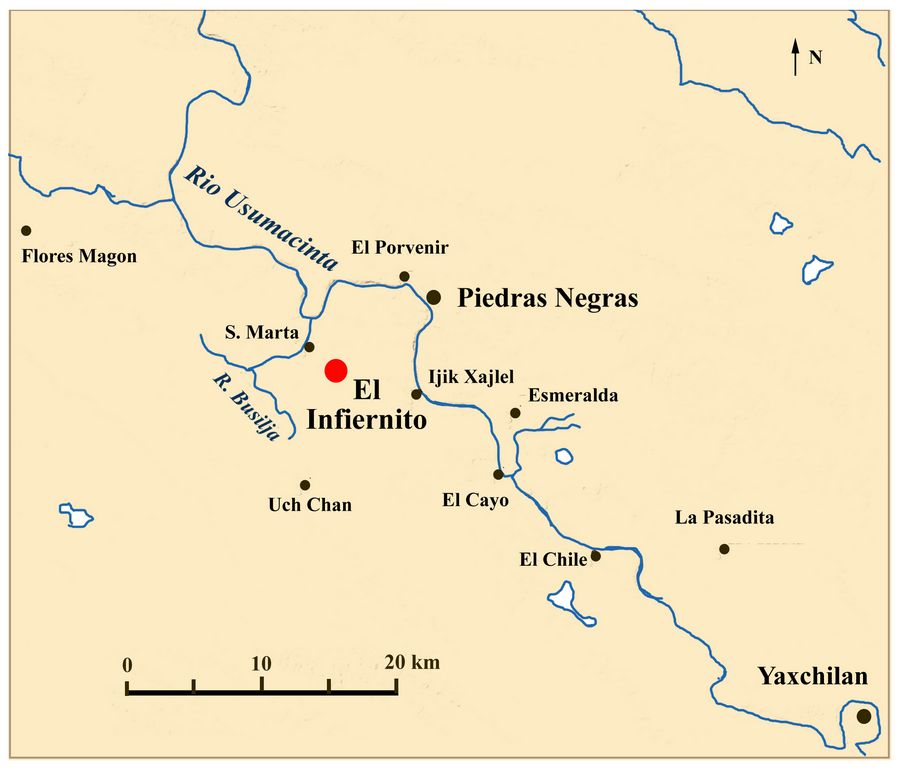
Fig.1: Location of El Infiernito
Previous Research
El Infiernito consists of multiple architectural groups, some of which are located at the summit of a hill measuring ninety meters in height, while others lie at the hill’s base. Preliminary excavations within the hilltop portion of El Infiernito suggest that the site was founded during the Late Preclassic period (300 BC-AD 200), abandoned, and finally reoccupied at the end of the Late Classic period, AD 750. This latter period corresponds with the Early Chacalhaaz ceramic phase of the region. Further excavations will test the extent of Late Chacalhaaz (AD 800-850) ceramics, which show considerable changes associated with the collapse of Piedras Negras, which took place in the first decades of the ninth century.
Funded Project in 2016 [RFF-2016-12]
2016 Goals
The main goals of the 2016 field season extended beyond El Infiernito to 1) document sites within 10 km of the Piedras Negras core to interpret regional settlement patterns, 2) map architectural clusters to establish a site typology for the Piedras Negras kingdom, 3) place test pits in patio groups and analyze recovered ceramics to understand settlement chronology, and 4) conduct horizontal excavations in select architecture to identify activity areas to investigate the role of minor centers in the political economy of larger urban centers.
In practice, during the 2016 field season, I addressed these goals only at the site of El Infiernito to narrow my dissertation research. The primary goal of the 2016 field season was to test two competing hypotheses, whether El Infiernito’s defensive location on a hilltop made it a crucial part of Piedras Negras’ military control of the region or if local populations chose to settle this region as a strategy of avoidance to resist such a state strategy. Findings this past season suggest that these two hypotheses are not necessarily competing, and both extremes may have existed in concert or at different times throughout El Infiernito’s history.
2016 Methodology
To meet these goals, a combination of methodologies was used, including archaeological survey, total station mapping, test pitting, and horizontal excavations. Focusing on the immediate region around El Infiernito’s epicenter, my team surveyed much of the land form where the site is located. This land form is a series of hills that form a crescent shape, with the bulk of settlement located along various local summits.
Results:
Survey:
One of the most interesting discoveries of the 2016 season were two monumental walls, one located near one of these summits and the other at the base of the hill, blocking off the gap formed by the natural crescent. Based on the lack of other architecture associated with these walls, their monumentality, and their similarity to other walls documented in the region, their main function was probably defensive. Indeed, both of these walls are located along one of the best routes for accessing the epicenter of the site. Other documented features include continued dense settlement along the crest of the hilltop.
Mapping:
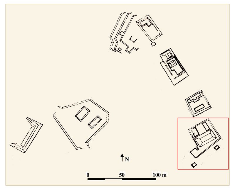
This involved the use of a total station and focused on two architectural clusters: the epicenter of the site on top of the hill and another large plaza at the base of
 the hill. These efforts expanded the extent
of the map to cover approximately 8 hectares, roughly half of the site
as we have defined it based on the shape of the hill. The current map
reveals that the upper portion of the site is composed of four large
architectural groups oriented along the shape of the hill, while the
lower portion is formed of three monumental platforms, one of which is
built into the side of the base of the hill and rises approximately 10
meters above the plaza.
the hill. These efforts expanded the extent
of the map to cover approximately 8 hectares, roughly half of the site
as we have defined it based on the shape of the hill. The current map
reveals that the upper portion of the site is composed of four large
architectural groups oriented along the shape of the hill, while the
lower portion is formed of three monumental platforms, one of which is
built into the side of the base of the hill and rises approximately 10
meters above the plaza.Fig.2: Map of El Infiernito (2016) with lower portion at left, and 4 architectural groups of upper portion at right; Group E is at south end (red box).
Test pitting:
To recover ceramics to establish the occupational history of the site, we placed test pits across the mapped portion of the site in patio areas. Many of these test pits showed a single phase of construction on top of bedrock, while others showed three phases of construction, reaching bedrock two meters beneath the current surface. Preliminary artifact examination in the fie
 ld suggests that the lower portion of the site
dates entirely to the Late Preclassic period (before AD 200) and the
upper portion dates mainly to the end of the Classic period (AD
750-800) with some evidence of occupation in the Terminal Classic
period (after AD 800 or even 850). However, some architectural groups
in the upper portion of the site appear to have evidence of Late
Preclassic or Early Classic (AD 200-500) period occupation, which would
suggest Preclassic period settlement was scattered along the base and
crest of the hilltop, while Late Classic period settlement was limited
to the summit, supporting the hypothesis that El Infiernito served a
defensive purpose, at least partially.
ld suggests that the lower portion of the site
dates entirely to the Late Preclassic period (before AD 200) and the
upper portion dates mainly to the end of the Classic period (AD
750-800) with some evidence of occupation in the Terminal Classic
period (after AD 800 or even 850). However, some architectural groups
in the upper portion of the site appear to have evidence of Late
Preclassic or Early Classic (AD 200-500) period occupation, which would
suggest Preclassic period settlement was scattered along the base and
crest of the hilltop, while Late Classic period settlement was limited
to the summit, supporting the hypothesis that El Infiernito served a
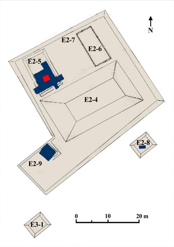
defensive purpose, at least partially.Fig.3: Excavation units (dark blue) in Group E at the southern end of the upper portion of El Infiernito
Horizontal excavations:
These investigations focused on a large platform within a patio group at the summit of the hilltop to recover evidence of activity areas and to determine the rate of abandonment. These excavations revealed a high density of metate fragments and ceramics, particularly storage vessels, suggesting a domestic function. Furthermore,
 horizontal excavations
revealed that the structure was made of wattle-and-daub, mainly
perishable materials on top of a dry, unworked stone masonry
foundation. Low stone walls also clearly delimit interior space, which
along with upcoming ceramic analysis will assign different functions to
the various rooms. Additionally, the abundance of material may point to
a rapid abandonment of this part of the site.
horizontal excavations
revealed that the structure was made of wattle-and-daub, mainly
perishable materials on top of a dry, unworked stone masonry
foundation. Low stone walls also clearly delimit interior space, which
along with upcoming ceramic analysis will assign different functions to
the various rooms. Additionally, the abundance of material may point to
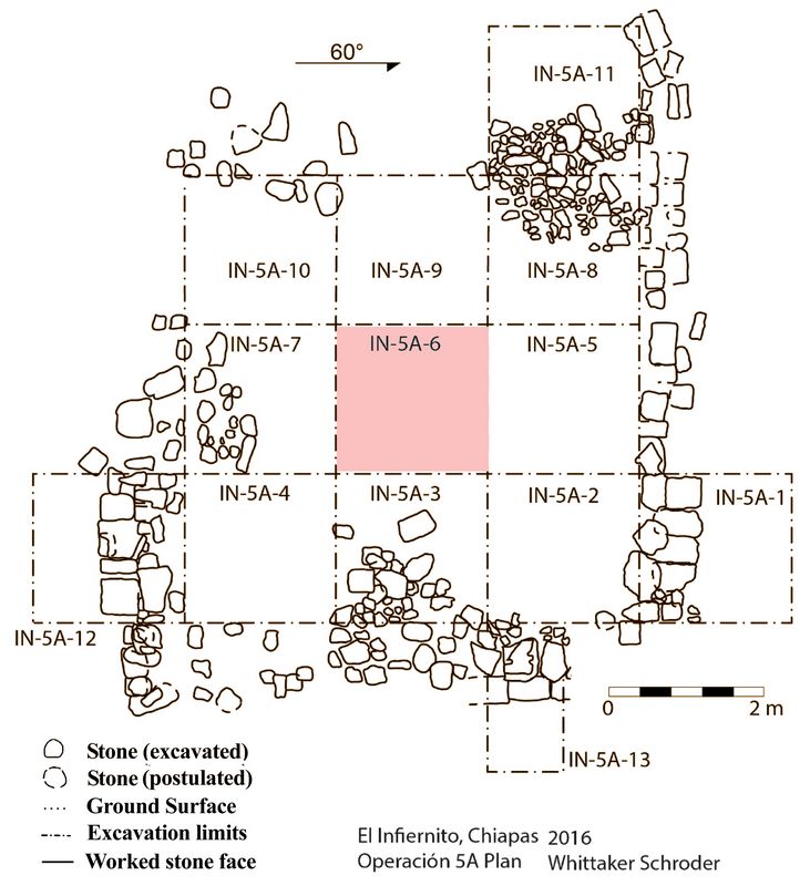
a rapid abandonment of this part of the site.Fig.4: Horizontal excavations showing exterior & interior walls of E2-5
After clearing a portion of the structure, we continued excavation below the most recent floor to examine earlier architectural phases. Once we reached the next floor the quantity of artifacts increased substantially, some located in fill, and others including carved seashell located in a small niche, probably an intentional cache placed before the construction of the final phase of the structure. The diversity of artifacts increased substantially, includi
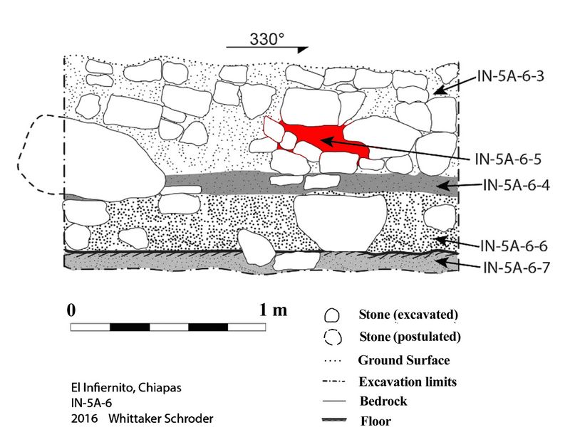 ng stone beads,
figurines, bone tools, and decorated ceramics, suggesting a major
change in the function of the structure from the penultimate to the
ultimate construction phase. The earlier phase appears to date to the
Late Classic period (AD 750-800), while the final phase may date even
later (AD 800-900). If this possibility is confirmed during laboratory
analysis, this final phase of construction would have taken place
approximately when Yaxchilan invaded Piedras Negras, desecrating the
royal palace in AD 808. In this scenario, El Infiernito would postdate
the collapse of the Piedras Negras state. With further horizontal
excavations, we may uncover more evidence to address how these crises
affected the inhabitants of El Infiernito.
ng stone beads,
figurines, bone tools, and decorated ceramics, suggesting a major
change in the function of the structure from the penultimate to the
ultimate construction phase. The earlier phase appears to date to the
Late Classic period (AD 750-800), while the final phase may date even
later (AD 800-900). If this possibility is confirmed during laboratory
analysis, this final phase of construction would have taken place
approximately when Yaxchilan invaded Piedras Negras, desecrating the
royal palace in AD 808. In this scenario, El Infiernito would postdate
the collapse of the Piedras Negras state. With further horizontal
excavations, we may uncover more evidence to address how these crises
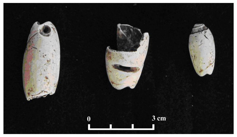
affected the inhabitants of El Infiernito.Fig.5 (above right): Stratigraphy of IN-5A-6 showing location of cache in red (IN-5A-6-5)
Fig.6 (below): Carved shell beads recovered from cache (IN-5A-6-5)
 Excavations
in 2016 suggest that El Infiernito may be able to fill in a
chronological gap in the region. Whereas most smaller centers within
the region rarely postdate AD 750-800, El Infiernito appears to have
been resettled at this time. Based on the timing of this resettlement,
my hypothesis that El Infiernito represented a refuge from the crises
associated with the collapse of the Piedras Negras state may still
stand. However, the more interesting question now is if El Infiernito
did serve as a refuge, who were the refugees? Though the architecture
at El Infiernito appears to have been built expeditiously, the
materials recovered are of a high quality, suggesting an elite status
for the site’s inhabitants. Did these people settle El Infiernito from
Piedras Negras, from other minor centers in the region that were almost
simultaneously abandoned, or from more distant regions such as the
Petexbatun? And what relation did these people have to the final phase
of occupation of the site, which at least at the moment seems distinct?
Excavations
in 2016 suggest that El Infiernito may be able to fill in a
chronological gap in the region. Whereas most smaller centers within
the region rarely postdate AD 750-800, El Infiernito appears to have
been resettled at this time. Based on the timing of this resettlement,
my hypothesis that El Infiernito represented a refuge from the crises
associated with the collapse of the Piedras Negras state may still
stand. However, the more interesting question now is if El Infiernito
did serve as a refuge, who were the refugees? Though the architecture
at El Infiernito appears to have been built expeditiously, the
materials recovered are of a high quality, suggesting an elite status
for the site’s inhabitants. Did these people settle El Infiernito from
Piedras Negras, from other minor centers in the region that were almost
simultaneously abandoned, or from more distant regions such as the
Petexbatun? And what relation did these people have to the final phase
of occupation of the site, which at least at the moment seems distinct?This field season demonstrated that horizontal excavations provide the data necessary to address these questions. Thus, the next phase of research will involve horizontal excavations of other patio groups at the hilltop summit to see if a pattern emerges across the site.
References:
Scherer, Andrew K., Charles Golden, Whittaker Schroder, Cyndi Medina Pimentel, and Pedro Guzman Lopez, 2013. Budsilha: Investigaciones en el Grupo Principal. In Proyecto Arqueologico Busilja-Chocolja: Informe de la Cuarta Temporada de Investigacion, edited by Andrew K. Scherer, Charles Golden, and Jeffrey Dobereiner. Submitted to the Instituto Nacional de Antropologia e Historia.
Recent Foundation grants: general Archaeology Grants Program w/map
Copyright © 2018 Rust Family Foundation