Rust Family Foundation: Archaeology Grants Program
Greater Angkor Project, Cambodia
[RFF-2016-06]Principal Investigators:
Sarah Klassen and Damian Evans, Arizona State University
Angkor was the capital of the Khmer Empire (9th-15th centuries CE). It emerged as one of the largest low-density urban complexes in the preindustrial world after a thousand years of gradual urbanization. Khmer inscriptions suggest that Jayavarman II founded the imperial kingdom in 802 CE when he pacified and united the Cambodian countryside. After unification, urbanism was rapid and expansive. By the 12th century CE the empire ruled most of mainland Southeast Asia and continued to flourish until the 13th century CE before entering a period of decline.
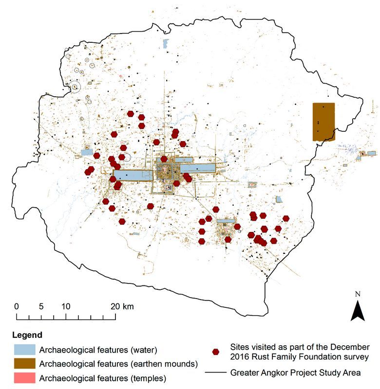
Fig.1: Archaeological sites visited as part of the December 2016 survey
The Angkor region extends over a thousand square kilometers in the flood plain of the Mekong River on lowland forest, heavy forest, and the alluvial fans of Tonle Sap Lake. It is characterized by a seasonal monsoon climate, with ninety percent of rainfall occurring between May and December. In response to these stressors, a complex hydraulic system with channels at lengths of over 20km and 40-60m wide, reservoirs with surface areas of up to 16.8km2, and 1000km2 of agricultural fields, was developed over the course of centuries. The scale of the engineered water management landscape at Angkor is likely unparalleled in the pre-industrial world and incorporates vast portions of the Angkor plain which remain scarred by remnants of ancient field systems, canals, and reservoirs (D. Evans, 2007).
In addition to what has been learned about its large and complex water management system, some research has been done on the administration and production communities at Angkor (Hall, 1985, 2011; Lustig, 2009; Mabbett, 1978; Ricklefs, 1967). There are over 1,400 temples scattered across the study area defined by the Greater Angkor Project as the region’s watershed. Temple communities were organized by the ruler or elites with royal sanctions, who provided lands, livestock, personnel, and built infrastructure in exchange for religious merit and material gain (Hall, 1985). These temples were integral administrative, economic, and religious centers for communities, regulating most aspects of Khmer life and are integral to unlocking an understanding of the functioning of the empire.
Now a World Heritage Site, in recent years Angkor has gained fame for its many temples, including Angkor Wat. Unfortunately, the new-found interest in the temples of Angkor and the associated rapid development of the region of Siem Reap for tourism is placing elements of the archaeological site in immediate danger of destruction. For this project, the investigators are working in collaboration with several well-established research programs, based in Siem Reap, Cambodia, to create a comprehensive map and consistent inventory of all known archaeological features within the Angkorian landscape. This map will include thousands of archaeological features that were revealed by the 2012 laser scanning (light detection and ranging, or lidar) mission and will be used to help identify areas of heritage significance with a view to enabling more effective conservation and management of cultural heritage at Angkor and beyond.
Previous Research
Angkor is a sprawling low density urban complex with hundreds of temples and occupation mounds connected through a network of infrastructure (D. Evans & Fletcher, 2015). Until recently, the true nature and extent of the settlement of Angkor was only partially understood. Much of the urban space was constructed in non-durable organic materials that have since perished; however, decades of aerial perspectives and remote sensing revealed traces of archaeological features including ponds, occupation mounds, embankments, and channels on the landscape (Damian Evans, 2007; Fletcher & Pottier, 2002; C. Pottier, 1999).
The current understanding of the medieval landscape of Angkor is informed by over 20 years of remote-sensing mapping projects. During two phases of mapping, Drs. Damian Evans and Christophe Pottier used satellite imagery and aerial photography to identify such features and created the most comprehensive map of Angkor to date (fig.1). This work greatly contributed to our understanding of Angkor as an urban landscape that extended far beyond the enclosure walls of famous sites like Angkor Wat and Angkor Thom.
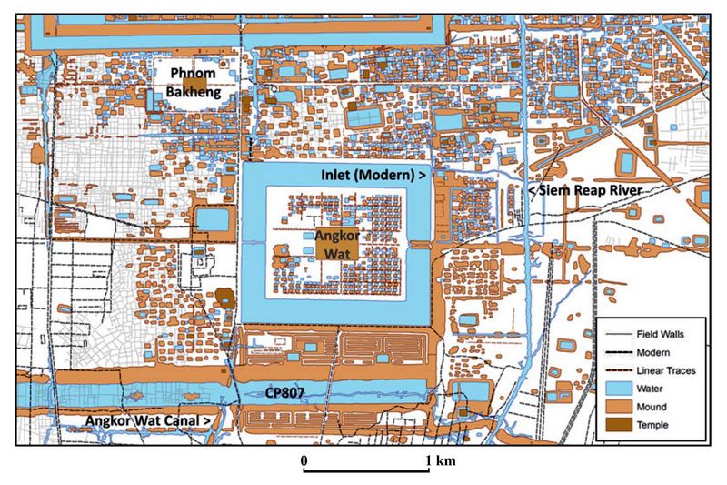 Fig.2: Mapping of Angkor Wat from lidar
data (Evans and Fletcher 2015: 1405)
Fig.2: Mapping of Angkor Wat from lidar
data (Evans and Fletcher 2015: 1405)Evans and Pottier were able to map much of the hinterlands but several areas remained obscured by dense vegetation, including the epicenter of medieval Angkor. In 2012, the Greater Angkor Project (GAP), an international team of researchers, and the Khmer Archaeology LiDAR Consortium organized a mission of airborne laser scanning (light detection and ranging, or LiDAR) across 370 km2 of the site. This technology was able to pierce the dense vegetation of Angkor and reveal the underlying ground surface. Initial analysis of the data, published in July 2013, revealed infrastructural complexity and extensive anthropogenic degradation (e.g., erosion) of the natural environment. The data has helped form a more complete spatial understanding of the urban space, including previously undiscovered residential, religious, and hydraulic features (D. Evans et al., 2013). Using the LiDAR data, over 19,000 previously unknown archaeological features in the urban core of Angkor were identified and mapped.
Project funded in 2016 [RFF-2016-06]
Goals:
The goals of the project were to: 1) Ground-verify archaeological features that were revealed and mapped with LiDAR data, using pedestrian survey, and 2) conduct ground penetrating radar.
Methodology:
Pedestrian Survey:
Over the course of the three weeks 60 sites were visited across 1500 km2 of the World Heritage Site (fig.1). The foundation for the ground-verification work was provided by decades of archaeological mapping work using aerial imagery, satellite imagery, advanced sensors that provided airborne radar data and the recently acquired lidar data (fig.2).
Sites slated for development and temple sites were prioritized. As part of the survey, over 40 temple sites were verified. Photographs were taken at each site and the types of building materials were recorded, as well as architectural elements including doorframes (fig.3), colonettes (fig.4), and lintels (fig.5), as well as artifacts such as pottery.
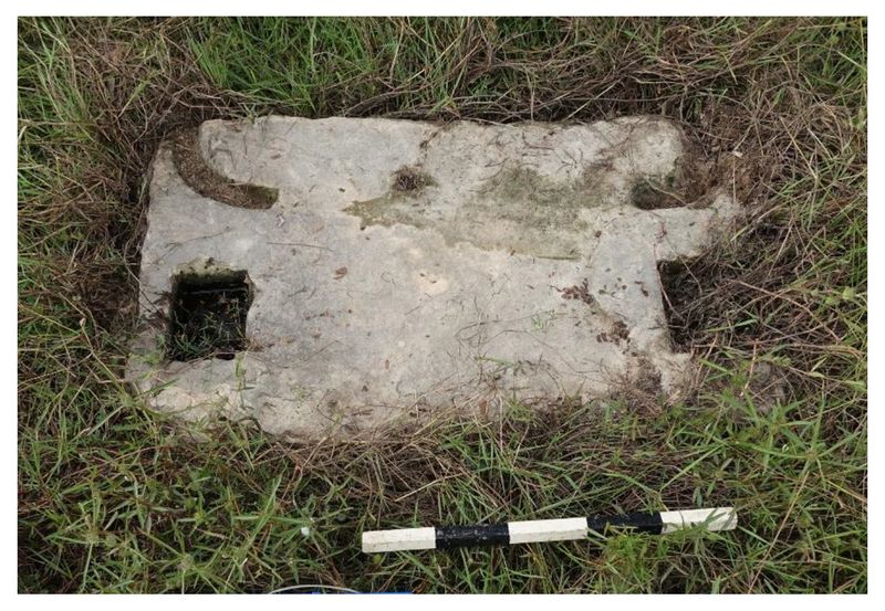
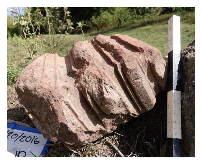
Fig.3 (left): Doorframe at site ID 100352
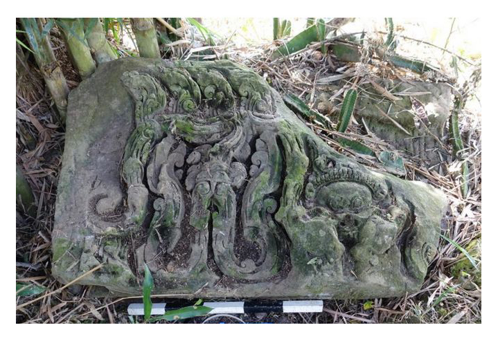
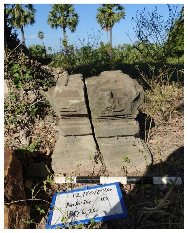
Fig.5 (left): Carved lintel at site ID 200548
Fig.6 (right): Pedestal at site ID 100626
In particular, pedestals were documented (fig.6) to be included in a typo-chronology currently being developed.
Ground Penetrating Radar (GPR):
GPR was conducted at the chute of the weir at Koh Ker, a Khmer political center about 80 km ENE of Angkor. The weir was first identified by Evans (Evans, 2013b) and is clearly visible in the 2012 lidar (fig.7). The weir consists of a 7-km long embankment across the old Rongea River valley. It is the longest water management structure across a river in Khmer history. The GPR was located to determine the nature of subsurface features revealed by the 2012 lidar and to help determine how and why the weir failed.
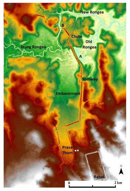
Fig.7: Embankment/weir to the north of Prasat Thom at Koh Ker. Imagery derived from the 2012 LIDAR mission.
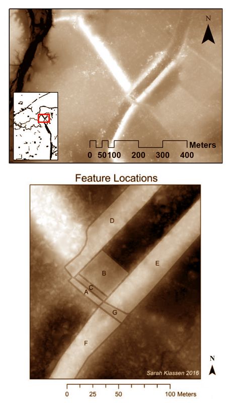
A rectangular structure (Features A and B in fig.9) appeared to obstruct the flow of water through the chute, and this posed the question of why such obstructions would be built to reduce the capacity of this vital piece of water infrastructure. To complete hydraulic models for the landscape of Koh Ker, it was necessary to determine what these features were and how they were meant to contribute to the operation of the water network. A further question was how the chute was impacted by or contributed to the known failure of the dam. GPR data was collected by Ian Moffat, a trained archaeologist and GPR expert, with a Malå X3M with a
 500Mhz antenna and the grid topography
was measured using photogrammetry data from a DJI Phantom 4 processed
using Agisoft Photoscan Professional.
500Mhz antenna and the grid topography
was measured using photogrammetry data from a DJI Phantom 4 processed
using Agisoft Photoscan Professional. Fig.8: Lidar imagery of the chute at Koh Ker.
Fig.9 (below): Features revealed by the 2012 LIDAR mission.
Results of 2016 Project:
Funding from the Rust Family Foundation enabled the investigators to arrive at the following conclusions:
1) Mapping: First and foremost, this work has contributed to ground-verifying the archaeological features mapped in the Khmer Empire in Cambodia.
2) Urban Morphology: This research has contributed to urban morphology work conducted by Klassen as part of her dissertation with co-authors Evans and Jonathan Weed. For semi-supervised machine learning methodology to be successful, it was important to have attribute data for each of the temples (like building materials, architectural elements, and artifact types). The survey work filled holes in pre-existing datasets and enabled the extension of the model to include 40 additional temple sites.
3) Pedestal Typology: Pedestals located on the survey have been incorporated into a pedestal typology currently being developed by Ruby Kerwin under the close supervision of Sarah Klassen.
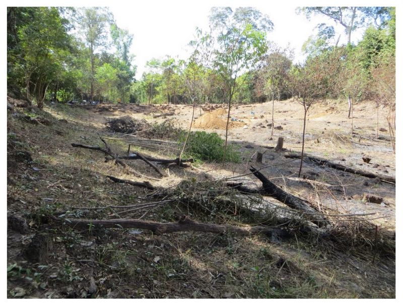 Fig.10: The cleared chute at the weir at Koh Ker.
4) Ground Penetrating Radar: GPR data from the chute indicates that the depth to laterite becomes progressively more variable with increasing distance down the chute from the spillway. We interpret this to reflect the increased plucking of blocks from the spillway by water flow, which are presumably deposited further downstream. It is difficult to assess if any of the blocks have been replaced in their original position during repairs to the chute but, it is clear, that any repair work did not address many of the block removal events. This suggests that the capacity of the chute was too small, which contributed to the failure of the weir. The quality of construction of the rectangular structure (features A and B) was poorer than that of the chute spillway, and it seems to have been built with four or five layers of laterite blocks. These appear to have been taken from the spillway after it was no longer operating. It is not a hydraulic control structure, as its level is too high to allow any appreciable flow downstream.
The data produced because of this project have been incorporated into a sophisticated typo-chronological database of archaeological features, which will help to facilitate more complex modelling of the development of archaeological landscapes in the area. The project is fundamentally interdisciplinary, involving archaeologists, technical specialists, engineers, hydrologists, heritage managers, IT professionals, and scholars from a range other fields. As evidenced by publications and presentations resulting from the project, the findings resonate well beyond the field of Angkorian archaeology, and provide new insights into the dynamic, long-tern relationship between humans and their environments in Southeast Asia and in tropical forest environments more generally.
References:
Evans, D. (2007). Putting Angkor on the Map: A New Survey of a Khmer 'hydraulic City' in Historical and Theoretical Context. (PhD Thesis) University of Sydney, Sydney, Australia.
Evans, D., Fletcher, R., Pottier, C., Chevance, J.-B., Soutif, D., Tan, B. S., Boornazian, G. (2013). "Uncovering archaeological landscapes at Angkor using lidar." Proceedings of the National Academy of Sciences of the United States of America, 110(31), 12595-12600.
Fletcher, R., & Pottier, C. (2002). "The Gossamer city: A new inquiry." Museum International, 54(1-2), 23-27.
Hall, K. R. (1985). Maritime Trade and State Development in Early Southeast Asia. Sydney: George Allen & Unwin.
Hall, K. R. (2011). The Temple-Based Mainland Political Economies of Angkor Cambodia and Pagan Burma, ca. 889-1300 A History of Early Southeast Asia: Maritime Trade and Societal Development, 100-1500. New York: Rowman & Littlefiend Publishers, Inc.
Lustig, E. (2009). Power and Pragmatism in the Political Economy of Angkor. (PhD thesis) University of Sydney, Sydney.
Mabbett, I. W. (1978). "Kingship in Angkor." Journal of the Siam Society, 66(2), 1-51.
Pottier, C. (1999). Carte Archéologique de la Région d'Angkor. Zone Sud. (PhD Thesis) Université Paris III - Sorbonne Nouvelle.
Ricklefs, M. C. (1967). "Land and Law in the Epigraphy of Tenth-Century Cambodia." Journal of Asian Studies, 26(3), 411-420
Recent Foundation grants: general Archaeology Grants Program w/map
Copyright © 2018 Rust Family Foundation