Rust Family Foundation: Archaeology Grants Program
Toward
an Archaeology of Empire: Mapping Inca and Wari Sites in the Nazca
Headwaters Using Drone Technology, Ayacucho, Peru
Principal Investigator: Bradley J. Parker
History Department and Center of Latin American Studies, University of Utah
Digital mapping from UAVs (Unmanned Aerial Vehicles) is revolutionizing archaeological research. Recent surveys utilizing this technology in southern Ayachucho province, Peru, have brought to light new data on the Inca and Wari empires that threaten to recast how archaeologists and historians understand the expansion and consolidation of not only the Inca and Wari empires, but ancient empires more generally.
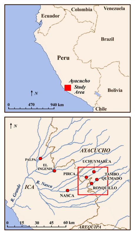
Fig. 1 (top right): Location of Ayacucho study area in southern Peru. (bottom rt): Map showing area of 2017 drone surveys (red square) in upper Rio Nasca drainage.
.
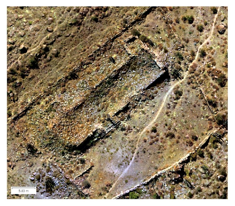
Previous Research in the region
Over the past seven years archaeologists from the University of California, Santa Barbara and the University of Utah have conducted archaeological surveys in the headwaters of the Nazca River in Ayacucho Province. These surveys have revealed an intricate and highly developed network of roads linking Wari and Inca centers near the city of Ayacucho (the Wari capital) with important provincial centers in the Sondondo Valley. Radiating west from this main corridor are lateral links to the valleys of the Nazca tributaries. These corridors are characterized by road stations (tambos) at specific intervals along main corridors, and by network hubs at the intersections of main and lateral corridors.
2017 Funded Research Project (RFF-2017-27)
Goals:
The primary goal of this project was to utilize drone technology to make detailed high-resolution orthographic maps and digital elevation models (DEMs) of five archaeological sites and one
 set of agricultural terraces in the headwaters of the Nazca river
in southern Ayacucho province in the southern Andes.
set of agricultural terraces in the headwaters of the Nazca river
in southern Ayacucho province in the southern Andes. Pedestrian survey methods were then used to "ground truth" the drone maps, to assess the accuracy and utility of the application of drone technology in the Nazca headwaters and for archaeological survey more generally.
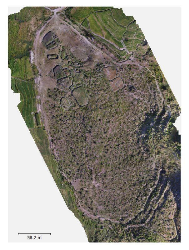
Fig. 2 (left): Overview of the site of Sokte, made from 476 photos from two sets of drone transects taken at 20 and 40 m. elevation. The site contains an Inca administrative building in an otherwise indigenous town (see also fig. 3 below).
The second goal was to test how the resulting data can aid archaeologists in site analysis, such as in estimating population by measuring the size and number of domestic structures at a given site, plotting variation through time by comparing site sizes and composition, and by calculating the productive potential of terraced fields. A related goal for completion in the near future is to bring the emerging data to publication.
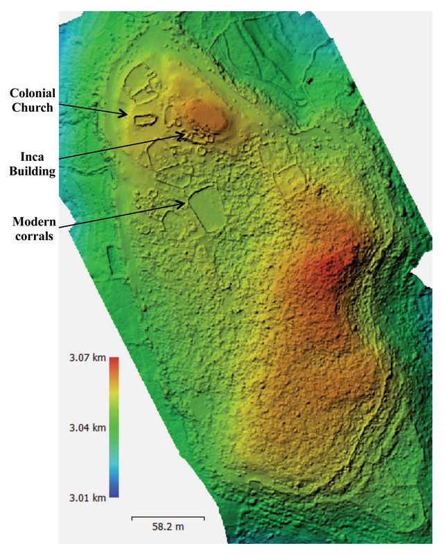
Fig. 3 (rt.): Digital Elevation Model (DEM) made from the same data as fig. 2. Defenses of the site are clearly visible as well as modern features such as animal corrals. The DEM is less effective at this site due to the vegetation that grew up as a result of last years’ el Niño. Nevertheless figure 4 (below) shows that architectural units can still be distinguished.
With only two small exceptions, the fieldwork goals have been met. The first exception is that one of the sites the project intended to map (Jeropukio) was not accessible due to the road being washed out by unusually heavy rains in parts of Peru in Spring 2017. A similar site, however, named Uchuytombo (an Inca tombo site) was mapped instead, with the consent of the appropriate Peruvian authorities.
Methodologies and Findings:
Field procedures involved site surveys using an unmanned aerial vehicle (UAV), specifically a DJI Phantom 3 UAV. From the digital images thus obtained, six very detailed high resolution maps were created of archaeological sites and (in one case) the surrounding productive landscape in southern Ayacucho province. The sites included one pre-Wari indigenous settlement (Calvario A), two Wari sites (
 Incawasi and Pataraya), one pre-Inca indigenous settlement (Tombo
Quemado), one Inca period colony (Sokta), and one Inca Tombo
(Uchuytombo).
Incawasi and Pataraya), one pre-Inca indigenous settlement (Tombo
Quemado), one Inca period colony (Sokta), and one Inca Tombo
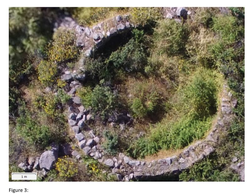
(Uchuytombo). Fig. 4 (left): Zoomed view of a single architectural structure from fig. 2., taken with the EXP 1300 digital camera on the Phantom 3 drone at 20 m elev., showing relative precision of individual features.
A lower resolution map was also made of the productive landscape (terraces and valley bottom) in the valley around Pataraya. The maps were produced on a laptop computer using Agisoft Photoscan Pro. This allowed most of the maps to be checked by walking a number of the sites in order to “ground truth” the accuracy of the maps, and inspect particular architectural units that had not been noticed before mapping.
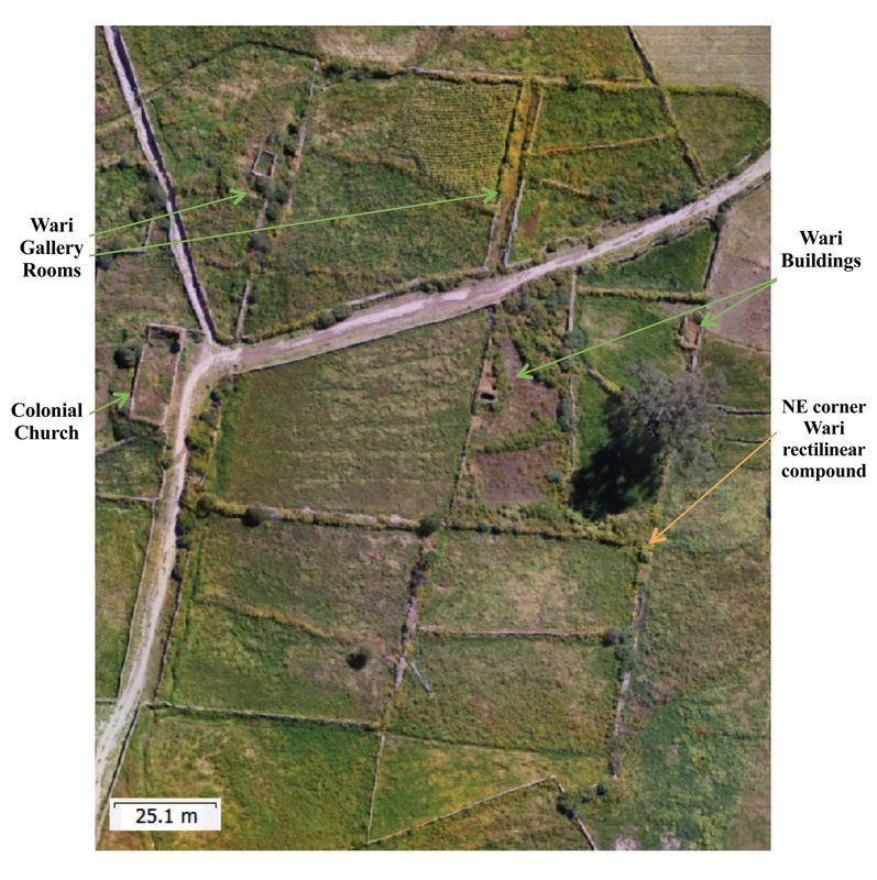
Fig. 5 (rt.): Orthographic map of the site of Incawasi made with a single set of transects at 50 m above launch point. Note the 6 square shapes dissected by the modern road. These structures were discovered by Schreiber and Edwards in 2007 and identified as poorly preserved Wari rectilinear administrative compounds. These compounds, which are about 50 meters on a side, are very difficult to see from the ground.
Among the findings revealed by the drone maps were a n
 umber of rectangular buildings at the site of Calvario. Subsequent pedestrian survey suggests these are a Wari
domestic structure or administrative compound. This appears to be an
appropriate area for future excavation. Secondly, at Sokte the drone
maps led to the indentification of a particularly well-preserved house
compound, which would also be an excellent place for future excavation.
umber of rectangular buildings at the site of Calvario. Subsequent pedestrian survey suggests these are a Wari
domestic structure or administrative compound. This appears to be an
appropriate area for future excavation. Secondly, at Sokte the drone
maps led to the indentification of a particularly well-preserved house
compound, which would also be an excellent place for future excavation.
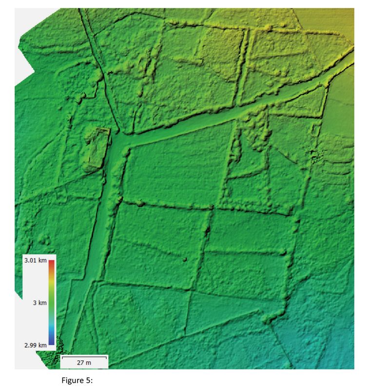
Fig. 6: DEM of Incawaasi. The square Wari compounds are even more obvious in the digital elevation model.
Conclusions:
Current research with UAV survey has provided detailed insights into the archaeological implications and possibilities of drone flying and mapping via drone technology. Experiments were done with overlapping transects at different altitudes, involving measurements of the accuracy and resolution of maps made at different altitudes by pedestrian survey. This has led to the drafting of a methodological article scheduled for publication next year.
Ongoing work with the maps created from the UAV imagery, and the digital elevation models (DEMs) made from those maps has led to a number of calculations about the targeted sites. These observations include:
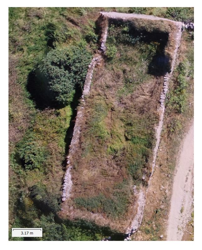
Fig. 7: View of the colonial church at Incawasi (also shown in fig. 4) which, taken from 50 m above launch point, still shows this structure in relative detail.
1) Utilizing drone technology to make maps of archaeological sites, and then ground truthing those maps by pedestrian survey, the present project demonstrates that extremely accurate maps of archaeological sites can be made in literally a fraction of the time it takes to make similar maps using traditional technology. Demonstration that maps made in this manner are extremely accurate has been done by physically measuring features on the ground which are then compared with measurements made of the same features on the maps.
2) Use of drone technology enabled the relatively rapid identification of areas and/or structures at several archaeological sites that may be promising places for further archaeological research (survey and/or excavation), including Calvario and Sokte. Maps made while in the field can be immediately used to visit said areas and structures, dem
 onstrating that UAVs are
valuable reconnaissance survey tools.
onstrating that UAVs are
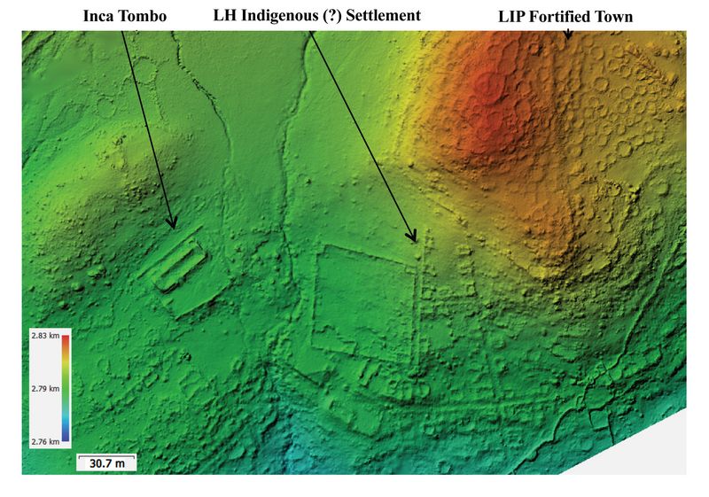
valuable reconnaissance survey tools.Fig. 8: Digital elevation model of Uchuytombo. In the upper right Late Intermediate Period round domestic structures surrounded by a defensive wall are clearly visible. In addition, an Inca Tombo is visible in the center left and a town, complete with streets, buildings and a large square compound is also clearly visible.
3) By counting the number and size of domestic structures at Tombo Quemado and Sokte, calculations could be made of the m
 aximum population of these sites
during the period immediately prior to Inca expansion (in the case of
Tombo Quemado) and during Inca occupation (in the case of Sokte). These
experiments suggest that it may be possible to utilize drone technology
not only to map architecture, but also to estimate population. Applying
this methodology to a wider region or to particular valley could lead
to a reasonably accurate picture of population fluctuations before,
during and after Wari and Inca imperial expansion and collapse.
aximum population of these sites
during the period immediately prior to Inca expansion (in the case of
Tombo Quemado) and during Inca occupation (in the case of Sokte). These
experiments suggest that it may be possible to utilize drone technology
not only to map architecture, but also to estimate population. Applying
this methodology to a wider region or to particular valley could lead
to a reasonably accurate picture of population fluctuations before,
during and after Wari and Inca imperial expansion and collapse.Fig. 9: Orthographic map of the newly discovered Inca tombo at Uchuytombo.
4) A current research project by a graduate student of the principal investigator, growing out of the 2017 findings in southern Ayacucho, seeks to calculate the productive capacity of the terrace system around the site of Pataraya. The method is to use modern data as a proxy for the potential productivity of terraced fields and then, by calculating the amount of
 space under cultivation from the drone maps, estimate the
potential output of these terraces in antiquity. The goal here is to
see if these terraces were meant to sustain local populations or if
they were meant to produce surplus for export.
space under cultivation from the drone maps, estimate the
potential output of these terraces in antiquity. The goal here is to
see if these terraces were meant to sustain local populations or if
they were meant to produce surplus for export.5) Also being studied are cost effective ways to create the types of maps and plans that can be used in standard paper publications from the UAV orthographic maps and digital elevation models. This is of course essential if drone technology is to be fully incorporated into standard archaeological practice.
Fig.10: Possible Middle Horizon tomb at Uchuytombo.
Recent Foundation grants: general Archaeology Grants Program w/map
Copyright © 2018 Rust Family Foundation