Rust Family Foundation: Archaeology Grants Program
Ban Qala: A Late Chalcolithic site in the Qara Dagh Valley of Iraqi Kurdistan
Principal Investigator: Antonietta Catanzariti
Post-Doctoral Fellow, Freer/Sackler Galleries, Smithsonian Institution
The site of Ban Qala (coordinates N 35.3431, E 45.44364), located in the Qara Dagh Valley of Kurdistan, Iraq, is situated on the northeastern sector of the valley at about 33.4 km south of the main city of Sulaymaniyah (fig.1). This was the first archaeological excavation conducted in this area of Iraqi-Kurdistan and the important results obtained will add to the significance and understanding of the archaeological sites of the Qara Dagh Valley and contribute to the field of Ancient Mesopotamia studies.
The Qara Dagh Valley is part of the Zagros Mountain ecoregion and has an altitude that ranges from 600-1650 m. The valley is enclosed by the Baranand and Qara Dagh mountain ranges and the highest peak measures 1800 m. From the valley, it is possible to reach the Shahrizor plain to the east by traveling through the Gilazarda passage in the Baranand Mountains. A series of winding roads lead to the Bazian plain in the north and the Darbandikhan region in the south. Ban Qala’s location in the valley was therefore optimal for regular circulation within the valley and to the regions surrounding the valley.
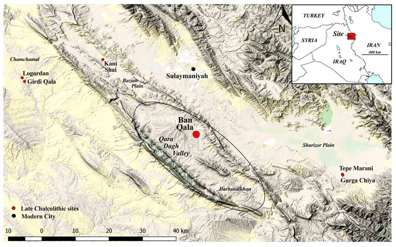
Fig.1: Location of Ban Qala and other Late Chalcolithic sites in Northern Iraq.
.
Previous Research in the region
Ban Qala was first identified in the 1940’s by Iraqi archaeologists but had not been
revisited until 2015, when the Qara Dagh Regional Archaeological Project (QDRAP) was able to document t
 he
site. At this time, the QDRAP performed a survey to collect diagnostics
necessary for a preliminary study of the settlement history of the
site. Due to the high presence of Late Chalcolithic period sherds, the
site was selected as the subject of an investigation for this period
and to understand the role of highland settlements in the Qara Dagh
Valley.
he
site. At this time, the QDRAP performed a survey to collect diagnostics
necessary for a preliminary study of the settlement history of the
site. Due to the high presence of Late Chalcolithic period sherds, the
site was selected as the subject of an investigation for this period
and to understand the role of highland settlements in the Qara Dagh
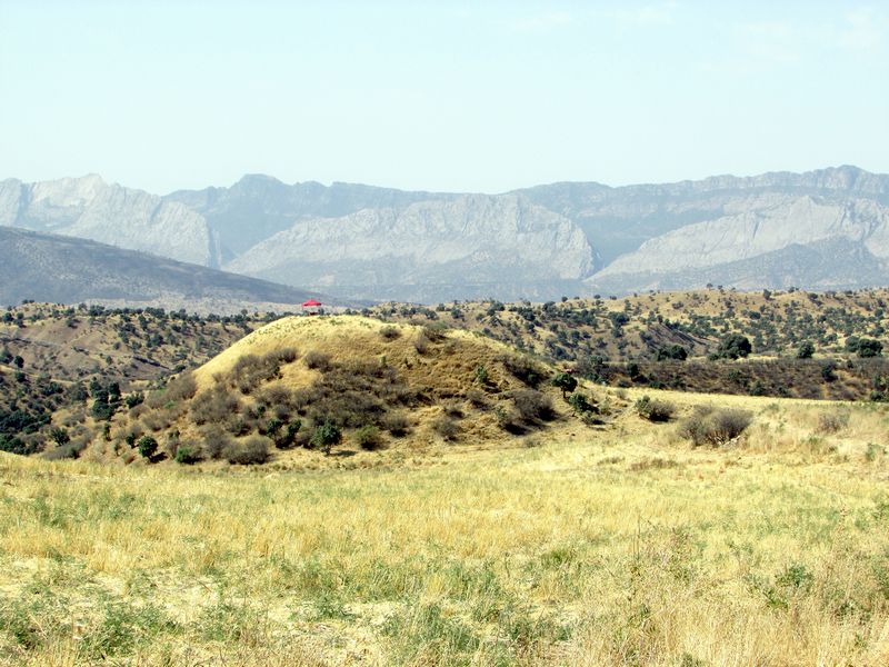
Valley.Fig.2: The Mound at Ban Qala
2017 Funded Research Project (RFF-2017-25)
Goals:
The excavation of Ban Qala took place in July 2017. The main research questions that guided this project were three: How were the Late Chalcolithic settlements that were located in the mountain region of Northern Mesopotamia impacted by the so-called Uruk Phenomenon? How did landscape affect the economic and social practices of Late Chalcolithic settlements? What relationships did Late Chalcolithic mountain communities sustain with the settlements located in the fertile plains of Northern Mesopotamia?
Methodology:
To respond to these questions, the team’s immediate priority was to begin a study of the occupation history of the site by opening a step trench on the southern slope of the mound. This was done in order to:
1) Reconstruct the stratigraphic sequence of the site, focusing on the Late Chalcolithic period
2) Begin a ceramic typology for the site that can be used as reference for other sites in the Qara Dagh Valley and be compared with sites located on the plain
3) Evaluate the relevance of the site for future excavation
The excavation took place on the southern slope of the mound (Fig.2), where three trenches (N100, N90, N80) measuring 4 m x 4 m were opened. The material from each trench collected was analyzed on site; 25 samples were shipped out of Iraq to undergo materials science analysis at the Smithsonian. In addition to the material culture collected, soil samples were retrieved and will be analyzed in the near future. The flotation of the samples will be performed in May 2018.
Findings:
Excavation Area and Data interpretation:
Trench N100
The first trench opened was Trench N100 on the upper, southern edge of the mound, the highest point of the tell. Although the upper layers of the site were heavily eroded and damaged by looting activities, this area of the mound was better preserved. Several pits characterized the upper layers of the trench. The largest pit (locus 5), measuring circa 2x1 m, was located north of the trench and cut through a wall feature (locus 20). The sherds collected in these layers have allowed us to determine that the pit (locus 5) can be dated to the mid-third millennium BCE. In addition, animal bones and spindle whorls were recovered in this area.
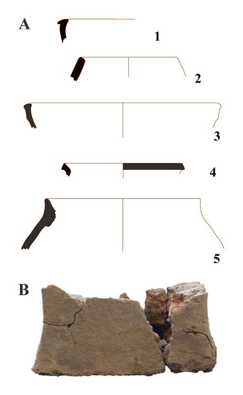
The wall (locus 20), composed of two badly preserved layers of mudbricks sitting on a stone layer, was too heavily damaged to understand its function. Just south of the wall (locus 20), were exposed a tannur (clay oven) and a jar, the internal walls of which were characterized by burn traces (locus 12). Both the tannur and the jar were sitting above a rectangular clay object measuring circa 10 x
 5 cm (Fig. 3). This same area was characterized by
the presence of ash and charcoal residue which, along with the
tannur, indicate domestic activities were likely
taking place outside of the wall. The area west of the wall was
composed of compact grey and brick-like soil. Here, spindle whorls were
also recovered, suggesting that activities related to textile
production were being carried out at the site.
5 cm (Fig. 3). This same area was characterized by
the presence of ash and charcoal residue which, along with the
tannur, indicate domestic activities were likely
taking place outside of the wall. The area west of the wall was
composed of compact grey and brick-like soil. Here, spindle whorls were
also recovered, suggesting that activities related to textile
production were being carried out at the site.The clearing of the tannur (locus 12) revealed that the layer below was composed of a compact earth surface; while this area was being excavated, sherds belonging to Bevelled Rim Bowls (BRB hereafter) were exposed. In this same area, stone tools were collected, mainly sickle blades, scrapers and obsidian blades, indicating that we had reached a new phase of occupation of the site.
Fig.3: (A) Drawing of pottery recovered in N100 from Loci 5 and 12. The cooking pot numbered 5 was found together with a tannur. (B). Rectangular clay object recovered below the tannur.
Trench N90
During the excavation of trench N90, opened on the slope directly below N100, the rim of a bowl with a seal impression was recovered as the top soil was removed. Its presence indicates the existence of some form of administrative organization linked to the recording of goods for storing or commercial transaction.
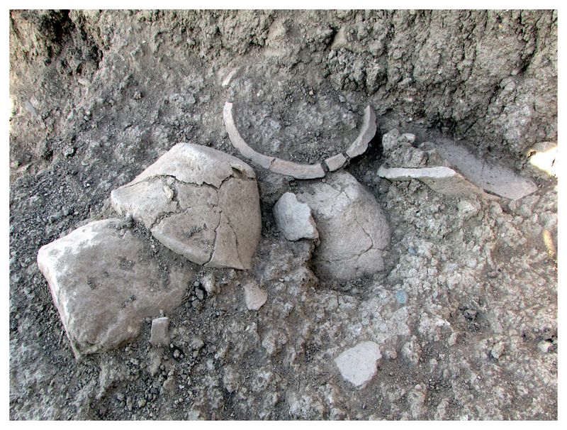
At 1 m below the topsoil, two clay, superimposed floors were identified on the eastern section of this trench. The floors continued toward the east of trench N 90. After the removal of the two floors, an additional layer composed of compact clay was exposed. The two clay floors suggest two phases of occupation that took place one after the other. Ceramic vessels and sherds recovered in this trench were mainly characterized by complete and broken BRB, two spouted jars and conical cup bases datable to the LC3-4 period (3799-3400 BCE).
 The context in which the majority of the BRB were
found in the western area of the trench can be interpreted as an area
used to discard such pottery. Circa six complete pots were exposed.
More are expected to be found east of trench N90. Of interest was the
presence of goat bones inside and around the bowls.
The context in which the majority of the BRB were
found in the western area of the trench can be interpreted as an area
used to discard such pottery. Circa six complete pots were exposed.
More are expected to be found east of trench N90. Of interest was the
presence of goat bones inside and around the bowls.Fig 4: Beveled Rim Bowls (BRB) found in Trench N90.
The recovery of the BRB has important implications, as it will allow us to collect data that will help understand the role of highland settlements in Northern Mesopotamian. An initial interpretation suggests that the presence of BRB at Ban Qala reflects the region’s exposure to cultural ceramic production trends circulating in Mesopotamia. The BRB from Ban Qala show regionalized characteristics and should not be conside
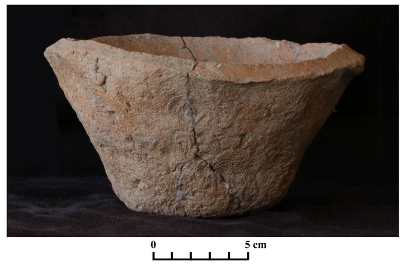 red as a
mere imitation of the BRB available in the north or south of
Mesopotamia. Although a common interpretation of these bowls is that
they were utilized as containers for rations or bread, they were
produced and valued for their strong functionality and multipurpose use (Le Brun 1980:66; Abdi 1999:223; Potts 2009:13).
red as a
mere imitation of the BRB available in the north or south of
Mesopotamia. Although a common interpretation of these bowls is that
they were utilized as containers for rations or bread, they were
produced and valued for their strong functionality and multipurpose use (Le Brun 1980:66; Abdi 1999:223; Potts 2009:13).Fig.5: Example of a Beveled Rim Bowl (BRB) from Ban Qala.
Trench N80
The last trench opened for the season was N80. Located directly below trench N90, N80 had a heavily eroded slope. As the topsoil was cleared, a child burial was found in the northwestern section of the trench. The bones of a child were placed in an open bowl with two perforations; the perforations indicate that the bowl was repaired and reused for burial purposes. The bowl with the bones was placed inside an internally hollowed jar.
The burial abuts a plaster floor uncovered north of the burial. Below the plaster floor were two layers of sherds (e.g. internally thickened rim open bowl with parallels from Tell Brak, Grai Resh [Matthews 2003, 47 n. 32; Kepinski 2011 Plate 14:4]) datable to the LC 2 period and stone tools (sickles and obsidian blades).
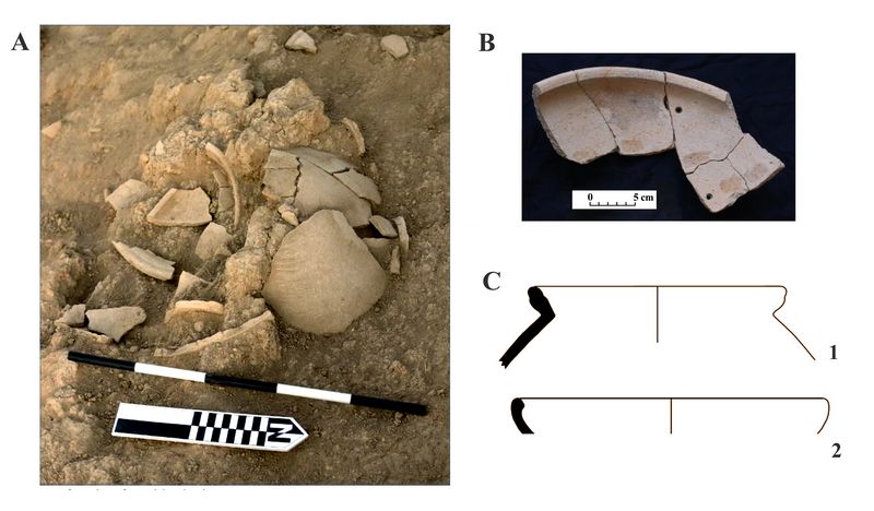
Fig.6: (A) Photo of Child Grave found in Trench N80. (B) Bowl with perforation found in the jar. (C) Drawings of burial jar (1) and bowl (2).
Both the plaster floor and the pottery were found adjacent to a stone wall with a southwestern orientation. The southern section of this trench was heavily eroded but, while removing the topsoil and eroded layers, an ash layer was identified, suggesting a phase of destruction. Below this ash layer, collapsed mudbricks were found, pointing to the existence of a damaged structure.
Conclusions:
The data collected in the first excavation season at the site of Ban Qala in the Qara Dagh Valley are an invaluable source of information in determining the role of highland communities in relationship to settlements located on the plains. The 2017 excavation findings indicate that Ban Qala had several occupational phases (table 1).
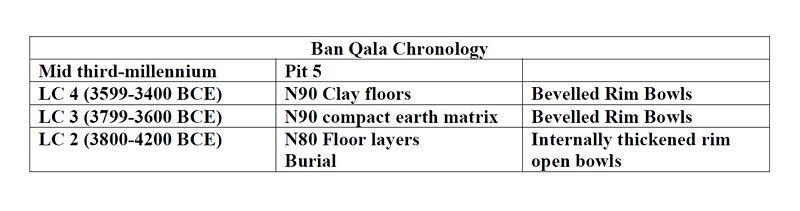
Table 1: Sequence of occupational phases at Ban Qala.
Ban Qala’s higher mound was occupied during the Late Chalcolithic 2-4 (3999-3400 BCE) period until the mid-third millennium BCE, at which time the site was abandoned and settlers moved to the lower mound. During this occupational period, the settlement engaged in different economic and administrative activities and transactions, as suggested by the presence of a seal impression on a rim and spindle whorls used for textiles production.
The recovery of Bevelled Rim Bowls (BRB), a hallmark of the Late Chalcolithic period, is often understood as the influence of southern Mesopotamian traditions in northern Mesopotamia, while at Ban Qala, the BRB indicates the settlement’s acquaintance with the cultural production trends circulating during the Late Chalcolithic period 3-4. Based on these findings, we may suggest that these vessels were not simple imitations of southern or northern forms but regionalized products. The Bevelled Rim Bowls recovered in trench N90 can be interpreted as being containers, the function of which was related to baking activities or for various other purposes. It is possible that these containers were not simply used once and discarded but were reused to contain other items, or used daily to contain food or food scraps.
In addition, the recovery of obsidian blades is indicative of a form of trade that allowed Ban Qala to have access to tools made with materials deriving from Anatolia. At this stage of the research, is it not possible to determine if the settlement had access to raw materials and was producing the blades, as the area excavated is not large enough to provide us with a complete view of the site. The presence of the finished obsidian blades suggests that Ban Qala received the final product of an object that required several production phases.
Finally, the presence of a child grave jar is an important discovery, the study of which will contribute to our knowledge on burial practices in the Late Chalcolithic of northern Mesopotamia. The pot mark displayed on the jar is an element that needs to be evaluated, particularly regarding its significance in relationship to the identification of the deceased.
The study conducted at Ban Qala provides a first time a look at the occupation history of the Qara Dagh Valley. This valley is often associated to the famous relief of Darband-di-Gawra of the end of the third millennium BCE, to the Sassanian remains at the Paikuli Pass and to the Lullubi, an ethnic group that lived in this region of Northern Mesopotamia and whose identity is yet to be understood. As the study continues, we will be able to provide a clearer understanding of this valley, filling some of the gaps in Northern Mesopotamian archaeology. Although the site is located in a valley that is enclosed by imposing mountains, it is clear that the settlement was not isolated and was actively participating in the cultural milieu of the Late Chalcolithic period.
Publications:
Abdi, K.
1999 “The Beveled-Rim Bowl: Function and Distribution.” In The Iranian World: Essays on Iranian Art and Archaeology Presented to Ezat O. Negahban” ed. A. Alizadeh, Y. Majidzadeh, and S. M. Shahmirzadi.Tehran: Iran University Press. (Persian, English summary pp. 222–23). Pp. 64–85
Collon, D.
2005 First impressions: cylinder seals in the Ancient Near East. London: The British Museum Press.
Le Brun, A.
1980 “Les écuelles grossières: État de la Question.” In L’archéologie de l’Iraq du début de l’époque néolithique à 333 avant notre ère ed. M.-L. Barrelet. Paris: CNRS. Pp. 59–70
Kepinski, C.
2011 New Evidence from Grai Resh, Northern Iraq- the 2001 and 2002 Seasons. A pre-Uruk Expansion Site from the Late Chalcolithic Period. Zeitschrift für Orient-Archäologie 4:26-81.
Matthews, R.
2003 Excavations at Tell Brak. Vol. 4. Cambridge: McDonald Institute for Archaeological Research.
Potts, D.
2009 Bevel-Rim Bowls and Bakeries: Evidence and Explanations from Iran and the Indo-Iranian Borderlands. Journal of Cuneiform Studies, Vol. 61 (2009):1-23
Rothman, M. S.
2001 Uruk Mesopotamia & its neighbors: cross-cultural interactions in the era of state formation. Oxford: James Currey.
Vallet Regis
2015 Report on the First Season of Excavations at Girdi Qala and Logardan. Antiquities Department of Sulaymenyah. Unpublished.
Stein, J. G. et al.
2013 “Preliminary Report on the First Season of Excavations at the Chalcolithic site of Surezha in the Erbil Governate Kurdistan Region, Iraq, 2013.” Iranian Archaeology 4:32-41.
Wengow, D., R. et al.
2016 "Gurga Chiya and Tepe Marani: New Excavations in The Shahrizor Plain, Iraqi Kurdistan". Iraq. 78: 253-284.
Recent Foundation grants: general Archaeology Grants Program w/map
Copyright © 2018 Rust Family Foundation