Rust Family Foundation: Archaeology Grants Program
Context for Exchange: Amazonian and Andean Interaction in Amazonas Province, Peru
Principal Investigator: Brian M. McCray, Vanderbilt University
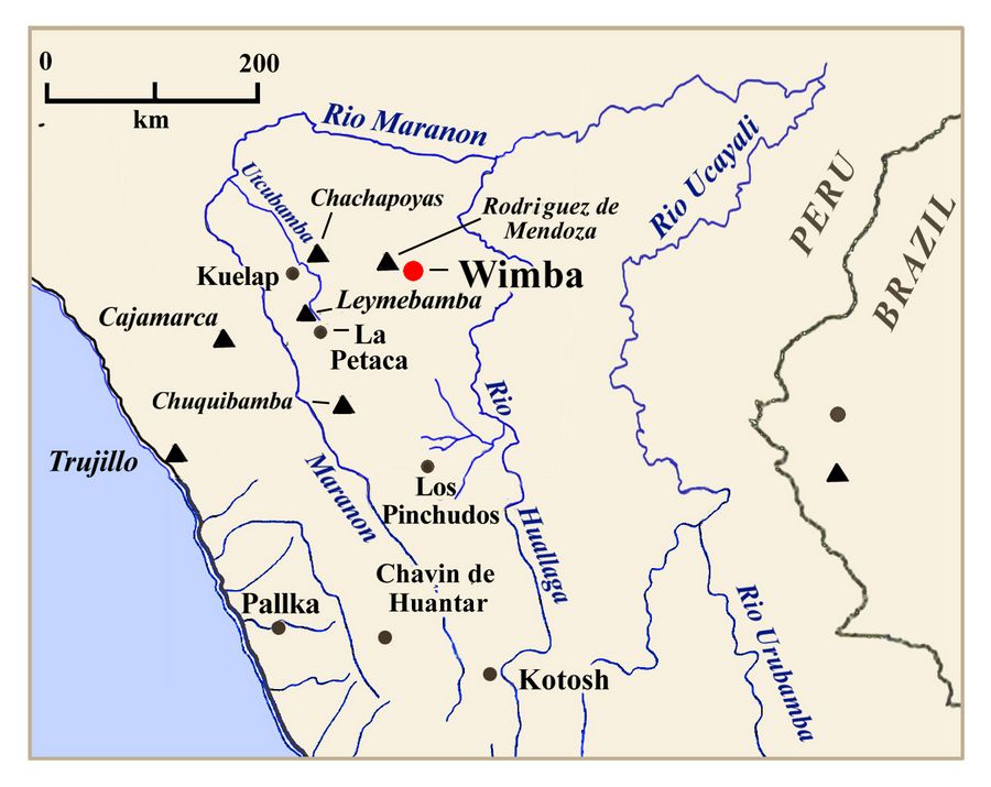
The archaeological site Wimba is situated in the montaña in Amazonas province, Peru, above the confluence of a river that was important for interregional transportation and communicatio
 n.
Wimba is one of the largest sites in the region, and contains a large
platform that may have been the venue for communal gatherings. Since
Wimba is located at low elevation and along a movement corridor, it
seems ideally suited to examine the hypothesis that communal gatherings
involving local residents, neighbors and/or traders facilitated the exchange of goods and ideas between the Amazon and Andes.
n.
Wimba is one of the largest sites in the region, and contains a large
platform that may have been the venue for communal gatherings. Since
Wimba is located at low elevation and along a movement corridor, it
seems ideally suited to examine the hypothesis that communal gatherings
involving local residents, neighbors and/or traders facilitated the exchange of goods and ideas between the Amazon and Andes.Fig.1: Location of Wimba in northern Peru.
.
Previous Work
Earlier surveys of the region were conducted by Schjellerup et al. (2003), as well as by the present researcher (McCray n.d.). The region served as an important corridor for Inka imperial administration seeking to control interaction with the Amazonian lowlands by constructing way stations and administrative sites along pathways to the lowlands. Schjellerup et al. (2003) attributed numerous sites to the Chachapoyas culture, dating to the Late Intermediate Period (LIP; AD 1000-1475) immediately preceding the Inka empire. The Chachapoyas culture primarily existed to the west of the Mendoza region where Wimba is located.
Initial survey work at Wimba was conducted in 2012 and 2013. While only a small number of ceramics were recovered through survey, the architecture visible on the surface at the site differs from typical Chachapoyas sites (McCray 2015). Though it is much smaller in scale, Wimba has a few features in common with Kuélap, the most well-known Chachapoya center, and one that is famously fortress-like. First, Platform 1 is surrounded by high stone retaining walls, 1.5 to 3 meters in height. Second, the entryway is a ramp, flanked by stone walls. Within Platform 1 certain spaces are delineated by retaining walls as well as large rock outcrops.
2016 Funded Research Project (RFF-2016-15)
Goals:
The main goals of the Proyecto Arqueológico Wimba in 2016 were as follows:
1) Map the Wimba site, including: a) platforms, b) structures, c) landscape features, and d) elevation points.
2) Perform test excavations on the platforms, designed to: a) test open areas with linear operations (similar to trenches); b) test structures by opening up most of the interior.
3) Analyze excavated materials, in order to document exchange goods, and document evidence for communal gatherings such as feasting, ritual, or trade fairs.
Methodology:
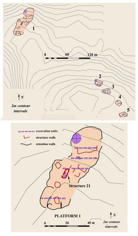
The first phase of data collection created a comprehensive map of the platforms at Wimba with a total station (Nikon NPL-352 and NPL-322) as well as GPS kit mapping application. Architecture visib
 le
on the surface was cleared and photographed. Elevation points were
taken to create a relatively precise digital elevation model of the
platforms (fig 2). Points were also taken to draw a cross-section of
the smaller platforms. This data was then analyzed with Esri
ArcGIS software to compare the various spaces at the site and their
relationships to adjoining structures.
le
on the surface was cleared and photographed. Elevation points were
taken to create a relatively precise digital elevation model of the
platforms (fig 2). Points were also taken to draw a cross-section of
the smaller platforms. This data was then analyzed with Esri
ArcGIS software to compare the various spaces at the site and their
relationships to adjoining structures.Excavation focused on exposing the various features discovered in the five mapped platform areas. Most operations consisted of multiple excavation units. Excavation was carried out by natural and cultural levels, terminating in sterile subsoil. Portable artifacts were collected for analysis and in situ artifacts and features were documented with photographs and scale drawings. Excavated soil was screened with ¼” mesh. 2000 cm3 soil samples were taken from all cultural levels for analysis of macrobotanical remains.
Fig.2 (top): Platforms 1-5. (bottom): Structures and excavation units on Platform 1.
Results of 2016 Research
Mapping the site was challenging due to its large size, thick overgrowth, and challenging topography. Clearing the 5 hilltop platforms uncovered some new features that had not been previously identified. Small storage structures were located on platforms 2-4. Also, platform 4 contained a large round structure with a distinct architectural style likely corresponding to an earlier occupation of the site.
Test excavations of Platform 1 consisted of five 1 x 3m units in an East – West line, separated by 1 x 1 m balks (fig.2, bottom) . Evidence was found on Platform 1 for at least four circular structures, as well as five rectangular structures. Test excavations in the northern portion of Platform 1 uncovered evidence that the largest structure at the site was open facing the public space at the north end of the platform, and raised up above the open space as well. This is strong evidence that this structure had a public purpose and use. Similar architectural features known from elsewhere in the Andes include Inka rectangular structures, sometimes called kallankas, which were associated with public spaces and used in times of inclement weather to celebrate public rituals.
South of Platform 1, between Units 2 and 3 of Operation 2 were found abundant camelid and ceramic remains in a deep deposit; a disarticulated camelid above a broken ceramic vessel, encircled by a ring of stones; and the remains of two walls below the current surface of the soil. The presence of this quantity of camelid remains at this elevation is unique and could be seen as evidence for feasting and ritual at the site.The other units of this operation were also rich in ceramic artifacts. Overall, this operation had the greatest density of non-diagnostic sherds by volume.
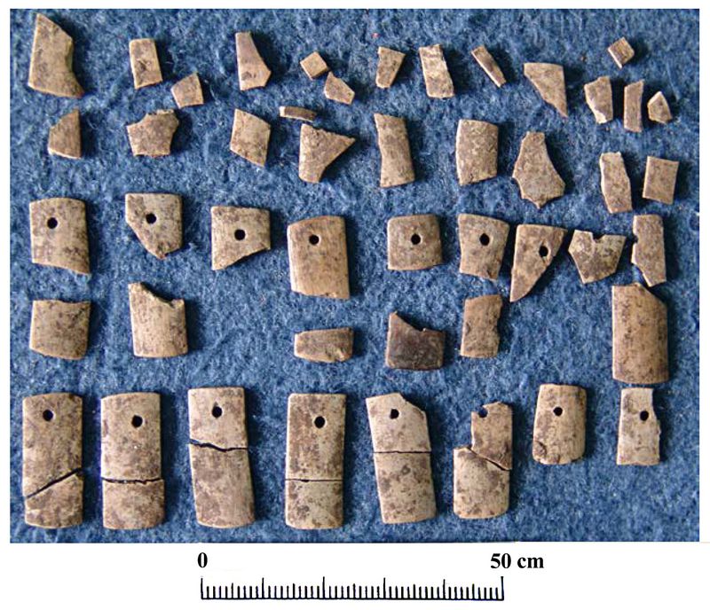 Excavations in both Operation 2 and Operation 7 also uncovered evidence of an earlier occupation of the site. Wall remains were buried by cultural fill to create the use
surface corresponding to the majority of architecture visible on the
surface today. This earlier occupation at Wimba was distinguished by
different architectural masonry style, different floor preparation, and
was associated with a group of bone pendants in Operation 7 (Fig.3).
Excavations in both Operation 2 and Operation 7 also uncovered evidence of an earlier occupation of the site. Wall remains were buried by cultural fill to create the use
surface corresponding to the majority of architecture visible on the
surface today. This earlier occupation at Wimba was distinguished by
different architectural masonry style, different floor preparation, and
was associated with a group of bone pendants in Operation 7 (Fig.3).Fig.3: Bone pendants found on Platform 4
Further radiocarbon dating will help determine the relationship between these two occupations. The most likely scenario is that the early occupation corresponds to the Early Intermediate Period (EIP; 0 – 500 AD) or Middle Horizon (MH; 500-900 AD), and the architecture visible on the surface corresponds to the Late Intermediate Period (LIP; 900-1475 AD) and Late Horizon (LH; 1475-1530 AD). Alternatively, the transition could correspond to the LIP to LH. This is one of the most intriguing finds from the project, as no archaeological evidence for pre-LIP occupation of this section of the montana has been previously found.
Operation 9 in Platform 4 exposed the largest round structure at the site.This had a relatively shallow layer of cultural fill (~15 cm), before bedrock outcrops were uncovered, including one large boulder with an unusual hole in the middle. This structure included a large quantity of ceramic fragments, lithic fragments, worked bone, and mineral remains (likely hematite). This large round structure was likely not a domestic structure, but rather may have involved lithic production, as lithic mace-head “wasters” were found here. The presence of foreign minerals, and a bone pendant fragment may be evidence of trade or exchange.
Excavations also revealed possible evidence of warfare at the site, possibly related to the abandonment of the site in the Late Horizon (AD 1475 to 1530) or early colonial period (AD 1530 to 1600). Excav
 ation
of Structure 1 uncovered lithic mace heads, and mace head “wasters”
that suggest production of these implements occurred here on Platform
1. It is difficult to define a particular use for
these, though they could have been agricultural or warfare related.
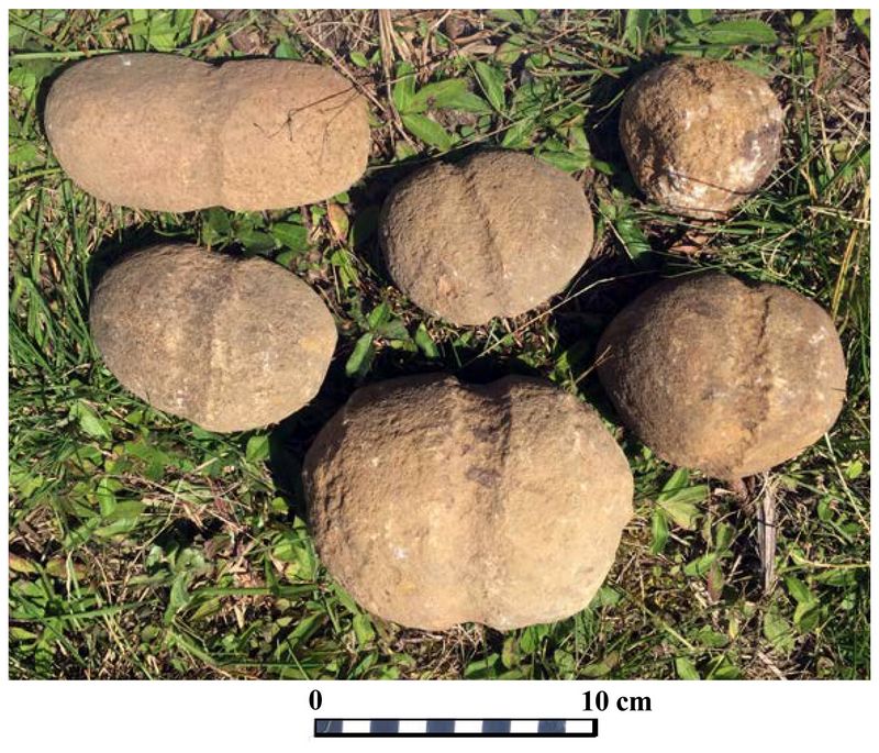
Upper levels of excavation on Platform 1 also included “boleadores”,
stones with a worked groove around the center to attach rope (Fig. 4) which could have been used in both hunting and warfare.
ation
of Structure 1 uncovered lithic mace heads, and mace head “wasters”
that suggest production of these implements occurred here on Platform
1. It is difficult to define a particular use for
these, though they could have been agricultural or warfare related.
Upper levels of excavation on Platform 1 also included “boleadores”,
stones with a worked groove around the center to attach rope (Fig. 4) which could have been used in both hunting and warfare.Fig.4: “Boleadores” or grooved stones
Domestic activities were also likely occurring throughout the site as well. Large grinding stones were found on each platform, both in surface survey and in excavation. However, as very little lithic debitage, which is often associated with domestic contexts, was discovered, this conclusion is still unconfirmed.
Publications:
McCray, Brian M. n.d.
Bordes y interfaces de Chachapoyas en Rodriguez de Mendoza.
Schjellerup, Inge R., Mikael K. Sørensen, Carolina Espinoza, Victor Quipuscoa, and Victor Peña 2003
Los valles olvidados: pasado y presente en la utilización de recursos en la Ceja de Selva, Perú . The National Museum of Denmark, Copenhagen.
Recent Foundation grants: general Archaeology Grants Program w/map
Copyright © 2018 Rust Family Foundation