Rust Family Foundation: Archaeology Grants Program
Exploring Mortuary Landscapes and Social Complexity among Pre-Columbian Chachapoya of the Eastern Andean Mountains of Peru
[RFF-2016-14]Principal Investigator: Dr. J. Marla Toyne, Associate Professor, Department of Anthropology, University of Central Florida
Importance of the Project
The ancient Chachapoya (~AD 900-1532) of the high jungle of Peru placed prepared human mummy bundles into constructed collective tombs and individually crafted mausoleums along cliff faces, but also within large cave systems – thus constructing places of the dead above and below the spaces of the living. Thus they created and lived in a vertical landscape surrounded by their ancestors that was dynamically used and actively constructed. While these extreme locations have drawn a great deal of attention, we really know very little about how they were constructed, how long they were used for, and, moreover, who was being buried inside. There appear to be differences within the region, between caves and tombs, and the connection to local communities, and these relationships will be explored by investigating a selection of sites.
This project continues a long-term, multidisciplinary, and scientific investigation of funerary practices among the Chachapoya, developing techniques in vertical archaeology, mortuary archaeology, physical anthropology, archaeological sciences, engineering, and conservation, with the goals of exploring regional variation and temporal trends. The project consists of the selection of archaeological contexts that make up the two nearby monumental, almost vertical, multi-leveled mortuary complexes, La Petaca and Diablo Wasi, and the installation of rope lines using vertical progression techniques to be able to access safely these sites in order to photograph, register,
 map, and excavate in
detail a selection of these unique contexts. By collecting superficial
and excavated materials from test pits, we will be able to better
reconstruct the contents, construction processing, history, and
ultimately, the importance of these remains to the ancient Chachapoyas.
We hope to identify architectural and archaeological material culture
patterns across the highly visible cemetery space and understand how
and perhaps why these spaces were selected.
map, and excavate in
detail a selection of these unique contexts. By collecting superficial
and excavated materials from test pits, we will be able to better
reconstruct the contents, construction processing, history, and
ultimately, the importance of these remains to the ancient Chachapoyas.
We hope to identify architectural and archaeological material culture
patterns across the highly visible cemetery space and understand how
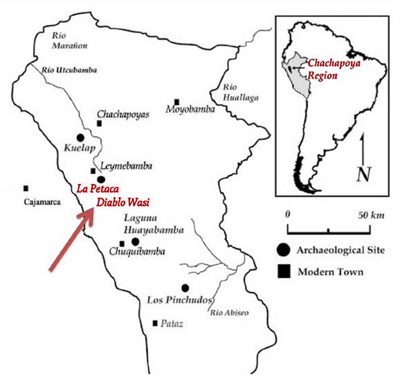
and perhaps why these spaces were selected. Fig.1: Map of South America including Peru, indicating the Chachapoyas region and major archaeological sites in the area.
Previous Research
Chachapoya archaeology on the northeastern slopes of the Peruvian Andes mountains of South America demonstrates a long history of regional occupation extending back thousands of years, though major sites are dispersed and significantly unstudied. More recently, Late Intermediate Period (AD 800-1470) and Late Horizon (AD 1470-1535) occupations are better understood due to archaeological investigations at a few sites including at Kuelap, a large monumental site centrally located in the Chachapoyas region, (Narváez Vargas, 1987; 1996; 2013). At Kuelap wall burials, subhouse floor pits, and collective stone tombs have produced a large skeletal collection analyzed by the PI over the past 12 years exploring questions of the skeletal health of these ancient Chachapoya people and providing a baseline for analyzing other Chachapoya burial remains (Toyne, 2006; 2011a; 2011b; 2015a; 2015b; Toyne and Narváez Vargas, 2014). Previous investigators have recognized the variation in mortuary practices in the region may signal intracultural differences, perhaps of socio-economic standing, ethnicity or some other symbolic identity yet few scientific field projects have been carried out. The incredible discoveries of well-preserved mummy bundles in large collective tombs at the Laguna de los Condores in the southern reaches of the Chachapoya region brought to light the invaluable wealth of material that has been preserved through the unique micro-climatic conditions along cliff faces (Guillén, 2002; Guillén et al., 2004; von Hagen, 2000). Sites such as these are rare, and devastated by aggressive looting. Yet these sites, even disturbed, can still provide vital clues to these little studied past cultures.
At the mortuary complex of La Petaca, located 14km south of the modern town of Leymebamba, the ancient Chachapoya placed the dead in collective cliff tombs along narrow ledges and in natural caves and niches across an exposed rock escarpment of over 12,000 m2. Over 100 human-made structures have been identified on the cliff face exhibiting different architectural styles, shapes, and sizes. Variation in these collective burial structures and the human remains within will be used as proxies for answering questions about the range of cultural complexity and patterns in social structure among and within different Chachapoya communities, intraregional variation, and social mobility. In a preliminary field season by the investigator in 2013, the preliminary techniques necessary for accessing several of the mortuary structures were developed. Through observations of photographs and using three rappelling lines vertically down the cliff face, it is estimated that there are at least 125 structures across the façade in the sectors that have been defined as the Superior and Southern. From a distance, many structures were all but invisible but up close the careful construction on narrow ledges can be seen, and surprisingly, many of the harder to reach tomb locations were thoroughly looted. Several were along lower horizontal ledges that could be accessed by walking, but most were along narrow ledges that were only accessible safely via vertical rope progression (rappelling). During that field season, only seven burial contexts (2 small caves and 5 disturbed tombs) were excavated due to the precarious nature of the site. In addition, five radiocarbon dates from different contexts were obtained, presenting a range of tomb construction and use beginning at least by 900AD through to 1550AD, but many more dates are required to better establish chronological variation in tomb type and location and use.
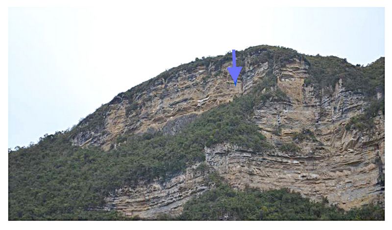
Figure 2. The archaeological mortuary complex of La Petaca. A vertical cliff face with hundreds of masonry tombs along narrow ledges. Blue arrow indicates the general location of tombs explored on the Superior Sector.
The urgency for this research has become evident in a recent visit to La Petaca, where the detrimental impact of erosion, both natural and human-made at the site were clearly visible. This is a fragile environment where high precipitation, winds, and the nature of the limestone geology results in fragmentation and collapse of ledges and the tombs upon them. Paint on the rock surfaces has begun to flake off naturally but tragically also because of careless previous explorers who inexplicably placed anchor bolts directly into the iconographic pictographs in the center of the cliff. There is a LONG history of looting of these tombs searching for artifacts and textiles that could be sold on the antiquities black market and considerable damage has been done to almost the entire site.
2016 Funded Research Project (RFF-2016-14)
Goals:
The placement of these mortuary structures demonstrates considerable effort of the ancient Chachapoya in placing the dead in inaccessible but visible spaces across the landscape. The goal of this research is to reconstruct patterns of access and construction of these sacred monuments using innovations in vertical archaeological techniques. Another key aim is to determine the ancient pathways and transportation routes of materials used in construction and deposition of remains including construction techniques of different structures, materials used and origin, architectural designs and recording, and interpretation of associated rock art paintings. These specialized houses of the dead also beg the question of who was being placed in these structures and distinctive locations compared to other cemetery locations. Finally, the variation observed within a single complex may reflect aspects of social organization or temporal patterns and thus reconstructing chronological events will further our understanding of change over time.
Methodology:
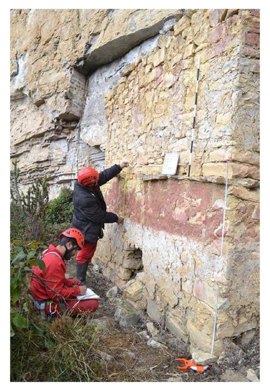
This project involved limited, direct excavation of the archaeological remains but focused on surface collection and innovative non-destructive survey and data acquisition strategies, including topographical and 3D mapping using photogrammetry, and registry of surface (exposed) materials and reconstruction of models of building techniques. In order to accomplish a complete detailed site plan of each site, cameras with a telephoto lens were used to shoot an abundance of overlapping images of the site from a distance. These images are being processed into a Gig-photo (massive file size) of the complete site with significant detail. Individually mounted GoPro© cameras were used to photograph in close up detail as many tombs from as many different angles as possible to create photographic data to digitize the shape, size, and features of the tombs using photogrammetry.
Vertical rope installations were established to access structures located in the center of the walls where there were no natural ledges and thus be able to use traditional archaeological methods including plan and profile drawings of burial architecture and artifacts, and collection of artifacts (ceramics, textiles, botanical remains, etc.) and human skeletal remains for analysis. Building materials (straw in the mortar) were sampled to provide the first clear evi
 dence to
determine temporal construction phases. Secondary and subsequent lab
work used bioarchaeological research techniques on the collected human
remains, including physical anthropological methods of skeletal
analysis, sample demography, and biochemical isotopic lab studies.
Skeletal observations included evidence of specific disease, dental
pathology, trauma, stature estimates, and activity markers that might
differentiate individuals of different social origins. These will be
interpreted in conjunction with archaeological methods of mortuary
analysis, architectural styles, ceramic analysis, and burial taphonomy,
to explore variability in Chachapoya population history, social
structure (differences in health and diet) and burial rituals.
dence to
determine temporal construction phases. Secondary and subsequent lab
work used bioarchaeological research techniques on the collected human
remains, including physical anthropological methods of skeletal
analysis, sample demography, and biochemical isotopic lab studies.
Skeletal observations included evidence of specific disease, dental
pathology, trauma, stature estimates, and activity markers that might
differentiate individuals of different social origins. These will be
interpreted in conjunction with archaeological methods of mortuary
analysis, architectural styles, ceramic analysis, and burial taphonomy,
to explore variability in Chachapoya population history, social
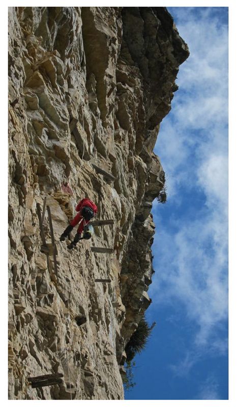
structure (differences in health and diet) and burial rituals. Fig.3: The use of vertical progression using ropes to ascend to the tombs to photograph and record tomb features and variation.
Results of the 2016 Project
The archaeological research completed during this project included recording (through photography and illustrations) and documenting archaeological mortuary structures and surveying their contexts. This research significantly advanced understanding of the zone and the possibilities for accessing different locations. However, the sites are very large and access was limited by the number of technical specialists and archaeologists participating as well as the natural environment. Nevertheless, selected excavations and the recovery of superficial materials from a few contexts from La Petaca, Superior sector, and Diablo Wasi, Central sector, enabled important discoveries and also greatly expanded our understanding of the variation of funerary practices at these sites.
Two structures at La Petaca EF-21 and EF-15 on the Superior Sector were investigated, including the creation of drawings as well as recovery of superficial materials from limited excavations. Very little materials remained within each structure. In addition, CF-03 (a newly discovered shallow burial cave) from the Superior Sector was investigated, mapped and superficially located remains recovered.
At Diablo Wasi, a previously unexplored site, four major exposed rock escarpments (North, Central, Superior, and South) with mortuary structures were also identified but not at the same density as La Petaca, and in fact included structures of a completely different morphology and decoration. On the Central Sector, there were at least 20 funerary structures and 3 small burial caves (completely looted). In the Central Sector, the vertical access was much more challenging and only one vertical rope system could be installed but this enabled access to t
 wo of the best preserved tombs structures with a significant
amount of well-preserved skeletal remains still within the tomb
(whereas most other tomb structures had been almost completely emptied
out). Burial structures along the base of the cliff along the
river bed, which were easy to access by walking were also recorded.
Drawings and materials were collected from 5 burial contexts. These are
the first scientific data acquired for this mortuary complex and
expected radiocarbon date samples and skeletal analyses will
significantly advance understanding of its history of use.
wo of the best preserved tombs structures with a significant
amount of well-preserved skeletal remains still within the tomb
(whereas most other tomb structures had been almost completely emptied
out). Burial structures along the base of the cliff along the
river bed, which were easy to access by walking were also recorded.
Drawings and materials were collected from 5 burial contexts. These are
the first scientific data acquired for this mortuary complex and
expected radiocarbon date samples and skeletal analyses will
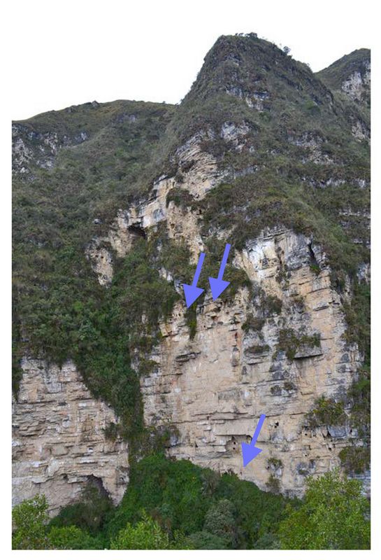
significantly advance understanding of its history of use. Fig.4: The archaeological mortuary complex of Diablo Wasi. The Central Sector contains at least 20 masonry tombs built into grottos. Blue arrows indicate the location of tombs explored.
At both sites, the human remains were ‘buried’, or better yet were placed within burial caves, overhangs, natural crevices, and within tomb chambers. Both complete and incomplete skeletons were accounted for (suggesting secondary burial of only parts of human skeletons). Remains include adults and children, males and females. However, the majority of the skeletons were disarticulated, disturbed, and damaged by taphonomic processes such as animals – carnivores and rodents chewing, birds nesting – as well as water, wind, plant roots, and soil acidity.
 At Diablo Wasi, the majority of well-preserved semi-mummified
individuals were no longer wrapped in associated textiles and very few
mortuary goods were present suggesting that even though the bodies were
not tossed out of the structures, these tombs were no less looted than
the others. However, due to the significant quantity individuals, it
was decided best to leave the majority of individuals in situ since we
did not have resources or participants enough to safely relocate the
materials to storage facilities nearby. At the same time, the
structural stability of the platforms upon which these structures were
built was unknown and physically entering the tombs may have put us at
considerable risk of causing the tomb to collapse.
At Diablo Wasi, the majority of well-preserved semi-mummified
individuals were no longer wrapped in associated textiles and very few
mortuary goods were present suggesting that even though the bodies were
not tossed out of the structures, these tombs were no less looted than
the others. However, due to the significant quantity individuals, it
was decided best to leave the majority of individuals in situ since we
did not have resources or participants enough to safely relocate the
materials to storage facilities nearby. At the same time, the
structural stability of the platforms upon which these structures were
built was unknown and physically entering the tombs may have put us at
considerable risk of causing the tomb to collapse. Fig.5: Archaeological mapping of a larger tomb chamber (fairly well-preserved and completely looted).
The burial structures had various forms but were mostly rectangular with straight walls and followed the narrow, natural ledges of La Petaca’s wall, but within shallow cave-like grottos at Diablo Wasi. Most structures were built on rectangular platforms, but the platforms of Diablo Wasi followed the V-shape of cracks and crevices. All structures were made of piled stone masonry, but with various sizes and methods for construction of the walls and finishing techniques. The stones appear locally quarried from the rock wall itself and most stones were additionally retouched in order to create flat surfaces and straight-edges for wall and corners. We observed generally even sized rectangular stones in parallel courses, irregular sized stones, and larger stones with smaller flat pieces as fill. Larger flat stones were used to create cornices, roofs, or entrance ways. In most cases, a mud mortar was used mixed with straw to increase structural integrity, and mortar was placed between stones in the walls, to even and smooth out entrance ways, and as part of roofing between wooden beams. Some structures also demonstrated evidence of plaster finishing creating smooth walls that were then painted – red and white – while others were painted directly on to the stone walls. Some structures were two stories and others had evidence of low wooden benches made of several thick tree branches. At Diablo Wasi, in particular, on the Central Sector, all structures appear to be decorated with architectonic niches built into the platforms and walls, creating horizontal tiers above the entrance ways in the form of ‘zig-zags’ or below the cornices with squares. Most of the Diablo Wasi structures also appear to have been painted red on white. However, preferential preservation of paint may have been due to the greater overhang of the Central Sector at Diablo Wasi and protection from the elements.
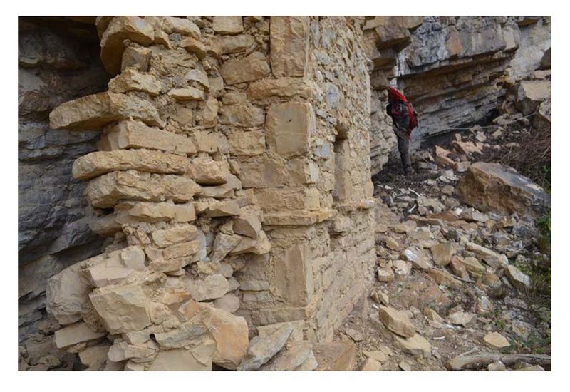
Fig.6: Tomb La Petaca EF-15 with architectural variation in masonry. The chamber of this tomb is well preserved, but the tomb next to it, EF-14 (left-hand structure in photo) has been destroyed, possibly by human looting or the natural erosion of the vertical geography.
Human remains within the caves and tombs appear to have been wrapped in textiles in a seated and flexed body position with few offerings, but only poorly preserved fragments remain associated with the disturbed skeletons. Due to looting and disturbance, we were not able to observe funerary offerings within the tombs or directly associated with individuals. Only a limited amount of material culture was recovered, including fragmentary ceramics and carved bone objects; a mate bowl; animal remains; wooden objects; and textile fragments.
Previously, we clearly noted as we descended the vertical ropes that many tombs could be aligned horizontally at La Petaca. We identified 5 to 6 different horizontal levels across the entire Southern sector. At Diablo Wasi, there were no clear horizontal ledges but tombs were constructed by enclosing natural cliff grottos. Access to these locations by prehistoric peoples is less clear, but irregular ledges may have been navigated. Clearly different methods were used in the creation of both sites, and may suggest chronological differences or cultural (ethnic or social) differences. Preliminary analysis of human remains between the two complexes suggest physical morphological differences (La Petaca were shorter on average), but ongoing paleopathological analyses may further serve to underscore health differences and therefore population origins or sources of those buried in either complex as well as compare to other sites in the region.
At both sites, we observed large areas of red paint on the natural rock surfaces in association with various archaeological structures and walkways. Red and white paint was also used to decorate the plaster finish on the buildings/mausoleums with white paint always below the red. Red was also used to paint rock art as outline figures symbolizing anthromorphic individuals, animals, abstract designs and a sun.
Even though these contexts have been looted and destroyed for many years, including evidence of prehistoric/historic looting, in addition to the natural taphonomic processes damaging the material remains (rock fall, animal activity, nesting birds, humidity, and tectonic activity), some of the contexts and materials are well preserved for observations and recovery. These sites urgently need more attention in terms of investigation and conservation. Not only looting but “local” or touristic exploration, will cause significant damage and increased rainfall in the area is already leading to further deterioration of the contexts and remains. There is also evidence of intentional human activities such as direct fires within structures clearly meant to destroy the contents. Continued scientific recording and preservation of materials recovered is essential to help conserve knowledge of these spectacular sites.
References:
Narváez Vargas A. 1987. Kuelap: “Una cuidad fortificada en los andes nor-orientales de Amazonas, Peru.” In: Rangel Flores V, editor. Arquitectura y arqueología pasado y futuro de la construcción en el Peru. Chiclayo: Universidad de Chiclayo. p 115-142.
Narváez Vargas A. 1996. “La fortaleza de Kuelap.” Arkinka 12:92-108.
Narváez Vargas A. 2013. “Kuelap: Centro del poder politico y religioso de los Chachapoyas.” In: Kauffman-Doig F, editor. Los Chachapoyas. Lima: BCP Coleccion de Arte y Tesoros Del Peru. p 87-160.
Toyne J.M. 2006. Análisis osteológico de los restos humanos recuperados de los mausoleos de Revash, zona de Santo Tomas, Chachapoyas, Perú. Report on file with Alfredo Narváez. Chachapoyas, Peru.
Toyne J.M. 2011a. Análisis osteológico de los restos humanos del proyecto especial de Kuelap, Chachapoyas, Perú. Proyecto de investigación, Etapa v. Report on file with Alfredo Narváez. Túcume, Peru.
Toyne J.M. 2011b. “Possible cases of scalping from northern prehispanic Peru.” International Journal of Osteoarchaeology 21(2):229-242.
Toyne J.M. 2015a. “Tibial surgery in ancient Peru.” International Journal of Paleopathology 8(0):29-35.
Toyne J.M. 2015b. “Variation in large ectocranial lesions from pre-columbian Kuelap, Peru.” International Journal of Paleopathology 11:30-44.
Toyne J.M., Narváez Vargas A. 2014. “The fall of Kuelap: Bioarchaeological analysis of death and destruction on the eastern slopes of the Andes.” In: Scherer. A.K., Verano. J.W., and Pillsbury. J., editors. Conflict, conquest, and the performance of war in pre-columbian America. Washington, D.C.: Dumbarton Oaks Research Institute. p 345-368.
von Hagen A. 2000. “Nueva iconografia Chachapoya de la Laguna de los Condores.” Iconos 4(2):8-17.
Recent Foundation grants: general Archaeology Grants Program w/map
Copyright © 2018 Rust Family Foundation