Rust Family Foundation: Archaeology Grants Program
Maya Agricultural Exchange:
La Florida and the Classic Maya Economy
[RFF-2016-11]
Richard M. Leventhal and Joanne Baron, Penn Cultural Heritage Center, University of Pennsylvania Museum of Anthropology and Archaeology.
La Florida and the Classic Maya Economy
[RFF-2016-11]
Richard M. Leventhal and Joanne Baron, Penn Cultural Heritage Center, University of Pennsylvania Museum of Anthropology and Archaeology.
Importance of the Project
Located on the San Pedro River in northwestern Guatemala, the Classic Maya site of La Florida had direct access to one of the region’s most important trade routes.
Fig.1: Location of La Florida and its relation to river courses and Tabasco plains (oval area).
La Florida’s position was advantageous for trade—here the river forms two sharp bends, slowing canoe travel. It is also situated at an ideal portage location between the San Pedro and Usumacinta Rivers, for any travellers wishing to avoid the Usumacinta’s dangerous currents. As noted by Shook (1943:24), “trade between the Usumacinta cities and Central Peten would almost of necessity pass La Florida, as would trade from the [southern] Usumacinta with the Tabasco plains area.”
Previous Research
Edwin Shook (1943) was the first archaeologist to visit the site and made a preliminary sketch map and notes. Sylvanus Morley visited the site the following year (Morley and Thompson 1944). Ian Graham returned in 1965 to map the site with tape and compass, make drawings of its monuments, and excavate a 1.5 x 1.5m test pit to the depth of one meter (Graham 1970). Paulino Morales returned in 1997 to make his own tape and compass map (Morales 1998) which has been the most accurate available map of the site until work by the La Florida Archaeology Project in 2015. The La Florida Archaeology Project has worked at the site since 2014 to explore and map its multiple groups.
Project Funded in 2016 [RFF-2016-11]
2016 Goals
During the 2016 field season, we conducted our first excavations with the goal of establishing the site’s settlement chronology and to look for evidence of trade with foreign regions, particularly the Tabasco Plains. Tabasco was a fertile agricultural zone, cross-cut by the San Pedro, Usumacinta, and Grijalva Rivers. It was particularly well known for its chocolate production, and home to some of Mesoamerica's most productive cacao orchards. We believe that La Florida served as a commercial port for these agricultural products in the trade between Tabasco and the central Maya lowlands.
2016 Methodology
We carried out test pitting in five areas of the site, shovel testing in nine, and surface collection in four. Ceramics obtained from different areas of the site pointed to a period of rapid settlement and construction around 600 CE or slightly earlier and an eventual abandonment around 800 CE. For a site the size of La Florida, such a short period of occupation was initially surprising, though it corresponds well with the known dynastic history of the site. Significantly, it also corresponds to a period of increased political activity in neighboring Tabasco, in which the powerful polities of Piedras Negras, Palenque, and Calakmul vied for control of the region. La Florida's construction history therefore indicates that its rapid settlement may be related to increasing integration between Tabasco and the rest of the Maya world, likely due to the desirability of Tabasco's agricultural products, especailly cacao.
 We
recovered imported Fine Orange pottery from Tabasco at La Florida's
eastern port of the Santa Marta. In the main part of the site, we also
recovered imported Fine
Cream pottery, likely from distant Veracruz. In addition, residents of
the local town of El Naranjo showed us several imported figurines from
Tabasco. All of these artifacts indicate that La Florida had extensive
trade contacts with Tabasco sites, which likely included cacao or other
cultigens as well. Apart from trade with Tabasco, we recovered pottery from the Usumacina River and the Highlands, pointing to the sites incorporation into an extensive trade network.
We
recovered imported Fine Orange pottery from Tabasco at La Florida's
eastern port of the Santa Marta. In the main part of the site, we also
recovered imported Fine
Cream pottery, likely from distant Veracruz. In addition, residents of
the local town of El Naranjo showed us several imported figurines from
Tabasco. All of these artifacts indicate that La Florida had extensive
trade contacts with Tabasco sites, which likely included cacao or other
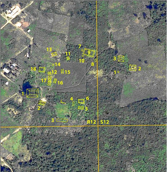
cultigens as well. Apart from trade with Tabasco, we recovered pottery from the Usumacina River and the Highlands, pointing to the sites incorporation into an extensive trade network.Fig.2: aerial view of the Santa Marta group.
While agricultural products such as cacao are difficult to detect in the archaeological record, the settlement history of La Florida, its strategic location on the San Pedro River, as well as the presence of various foreign
 imports point to the site's role as an intermediary trading center
between Tabasco's fertile agricultural zones and more distant trading
partners to the south.
imports point to the site's role as an intermediary trading center
between Tabasco's fertile agricultural zones and more distant trading
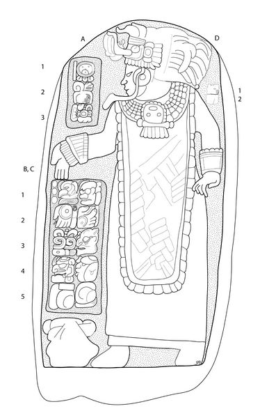
partners to the south.The most unexpected find of the 2016 field season was Stela 16 (fig.3). Measuring approximately 1.5 meters high, this stela depicts a woman in the act of scattering incense during a calendar ritual in 785 CE. It is the latest monument known at the site by 20 years. Interestingly, the image on Stela 16 is nearly identical to the larger Stela 9, dated to 731, which also depicts a royal woman. Stela 16 was recovered in the Santa Marta group, a small plaza of monumental architecture that overlooked a ort area where we recovered Fine Orange sherds from Tabasco. The presence of Stela 16 in this area and its resemblanced of Stela 9 demonstrate that the royal dynasty claimed cominion over this trading area.
Fig.3: Newly-discovered Stela 16 from the Santa Marta group.
.
References:
Graham, Ian
1970. The Ruins of La Florida, Peten, Guatemala. In Monographs and Papers in Maya Archaeology. William R. Bullard, ed. Pp. 427–455. Papers of the Peabody Museum. Cambridge, MA: Harvard University.
Morales, Paulino I.
1998. Asentamiento Prehispánico En El Naranjo-Frontera, La Libertad, Peten. In XI Simposio de Investigaciones Arqueológicas En Guatemala, 1997. Juan Pedro Laporte and Héctor Escobedo, eds. Pp. 128–143. Guatemala City: Ministerio de Cultura y Deportes, Instituto de Antropología e Historia, Asociación Tikal.
Morley, Sylvanus G., and J. E. S. Thompson
1944. Reconnaissance in Mexico and Guatemala. Carnegie Institution of Washington Year Book 43: 169–172.
Shook, Edwin M.
1943 Field Notes of Edwin M. Shook, Book 286. Department of Archaeology, Universidad del Valle de Guatemala.
.
Recent Foundation grants: general Archaeology Grants Program w/map
Copyright © 2018 Rust Family Foundation