Rust Family Foundation: Archaeology Grants Program
Excavations in Structure Selepan, El Tintal, Guatemala
El Tintal Archaeological Project
[RFF-2016-07]Principal Investigators:
Mary Jane Acuña, Washington University at St. Louis, and Francisco Castañeda, ETAP
The goal of the El Tintal Archaeological Project (ETAP) is to study the ancient city of El Tintal, located in northern Petén, Guatemala (Fig. 1). So far, our investigations have determined that the site was settled in the early Late Preclassic Period (ca. 400 BC) and was occupied through the Late Classic Period (AD 600-800/900).
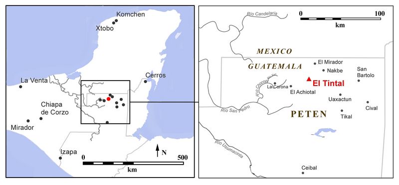 Fig.1. Location of El Tintal in northern Guatemala (C.R. Chiriboga, ETAP).
Based on archaeological evidence, Hansen (2012b:243) suggested that the state of El Mirador declined around the year A.D. 150, affecting the surrounding region as well. Preliminary investigations at El Tintal indicate that the events at El Mirador might be responsible for the noticeable reduction in construction activity in the Early Classic Period (A.D. 200 - 600). In addition to the apparent lack of investment in large public works in the Early Classic Period, the population at El Tintal did not adopt the tradition of carving and erecting stelae, which became popular after the 2nd century in the southern Maya lowlands. Thus far, there have been no discoveries of epigraphic texts pertaining to the Early Classic Period, with the exception of some glyphs carved into small portable objects found in the context of a royal tomb that was excavated in 2004 (Hansen et al. 2005). The tomb was dated to the Early Classic Period based on pottery styles, suggesting the presence of some kind or authority at the site during this enigmatic time.
Fig.2: Map of El Tintal, showing major mound groups and locations of canals (after Mejía et al. 2005:Fig. 1). Inset shows area of fig.3.
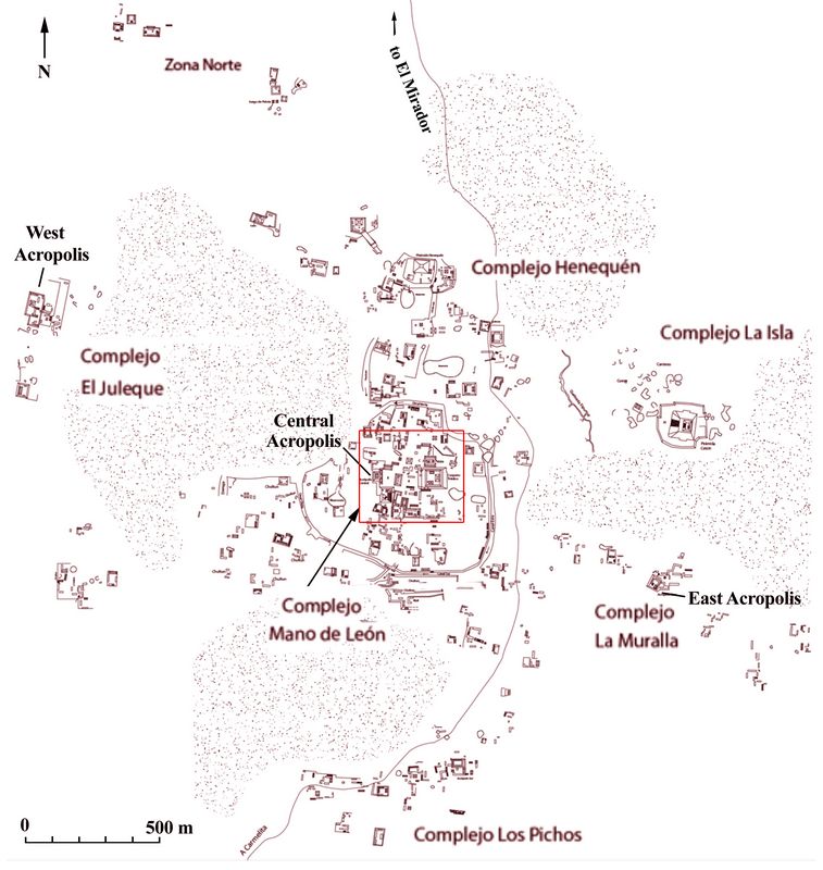
The visible settlement of the site today incorporates over 850 mounds distributed in architectural groups across the landscape and around bajos or low-lying, seasonally inundated areas (fig.2). The “Central Acropolis” was designated as such when the first schematic map of El Tintal was made (Mejía et al. 2005:172), based on the arrangement of buildings around Plaza B that consisted of a palace-style mound on the west, and the prominent, acropolis-looking mound closing the space on the south side (fig.3).
The group of buildings that form the Central Acropolis are of significance not only because of their size and monumentality, but because of their prominent location in the heart of the ceremonial precinct at El Tintal. Overlooking this group on the eastern side across Plaza A is the Triadic Group, which is considered a hallmark of Late Preclassic (ca. 400 BC – AD 250) architecture symbolizing political and ideological power (Velásquez 2014). Adding prominence to the ceremonial core of the city is the fact that it is surrounded, and therefore protected, by a series of artificial canals.
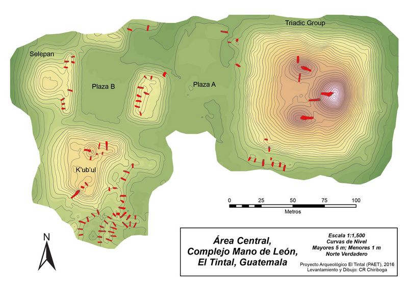 Fig.3: Plan
of the epicenter of El Tintal, showing the location of Structure
Selepan in relation to Plazas A and B, and the Triadic Group.
Fig.3: Plan
of the epicenter of El Tintal, showing the location of Structure
Selepan in relation to Plazas A and B, and the Triadic Group.Previous Research
During our first field season in 2014 research centered on establishing the mapping infrastructure by setting up a series of benchmarks throughout the core of the site, and excavations were limited to test pits in patios and plazas to gather chronological information (Acuña 2014). In 2015, in addition to continuing with the test pit program and mapping, ETAP began excavations in the Central Acropolis and Triadic Group, as well as in the peripheral architectural compound known as El Juleque (Acuña and Matute 2016). In 2013 and 2014, the El Mirador Basin Project, led by Richard D. Hansen, also conducted some archaeological investigations and mapping activities as part of their regional survey studies (Hansen and Suyuc 2014).
Structure Selepan, located on the western side of Plaza B, became a major focus of ETAP investigations when preliminary research began there began in the 2015 season (Castañeda 2016). These excavations exposed some architectural features that suggested the final construction episode was not very well preserved. Eight looters’ trenches that penetrated the anterior platform (range-structure) also destroyed significant portions of the architecture and destabilized the integrity of the mound.
Initial excavations in 2015 also began to define the architectural features of the final construction phase on the eastern façade of Structure Selepan, exposing sections of a staircase approximately 40 m wide. Additionally, a deep unit excavated at the top of the staircase into the platform revealed at least four construction sequences. The last three of these construction phases correspond to crude remodeling events that took place in the Late Classic Period. The fourth and earliest phase, which has only been minimally exposed to date, is an elaborate masonry building with plaster finish.
Project Funded in 2016 [RFF-2016-07]
Goals:
Funds from the Rust Family Foundation (RFF) were requested for the continuation of excavations in Structure Selepan. The actual function of the architectural compound remains unknown, but the urban context, layout and architectural disposition of the building suggest it was administrative in nature. The general research goal is to identify and study the different construction phases (episodes), the building’s function over time, and through this investigation contribute to the understanding of the site’s history. In addition to establishing the chronological sequence of occupation and use, we also diagnosed the building’s state of preservation, especially the damaged caused by looters’ in decades past.
 Methodology
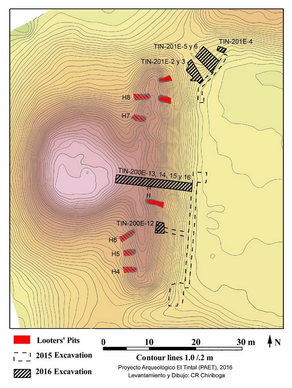
In 2016, the El Tintal Archaeological Project (ETAP) field season took place from April 27 through May 27 with a team of 44 people, including archaeologists, technical, and operational staff. The 2016 investigations included intensive (vertical) and extensive (horizontal/ surface clearing) excavations in Structure Selepan and the small platform abutted to the north, as well as the cleaning and documenting of five looters’ trenches (Fig.3).
Fig 4. Topographic map of Structure Selepan showing the location of 2016 excavations and cleaning of looters’ trenches (map by C.R. Chiriboga, ETAP).
Results of 2016 Research
Cleaning of Looters' Trenches
The cleaning process involved the removal of organic debris and accumulated collapse within the trenches, on the profiles and the floors, as well as the remains of loose backdirt to expose the original primary context left by looters. All artifacts were collected in this process even though their corresponding cultural stratum could no longer be known.
The cleaning of trenches allowed us to identify the posterior (west) wall of the rooms atop the front platform of Structure Selepan. The wall was built with stone blocks averaging 0.40 x 0.30 x 0.25 m, some of which had nicely cut sides. In all the trenches we were able to identify the plaster floor corresponding to the interior chamber(s) of the later platform. Unfortunately, the illegal excavations cut through large sections of the floor and severely damaged it. In the three trenches on the southern side of the mound we also were able to identify
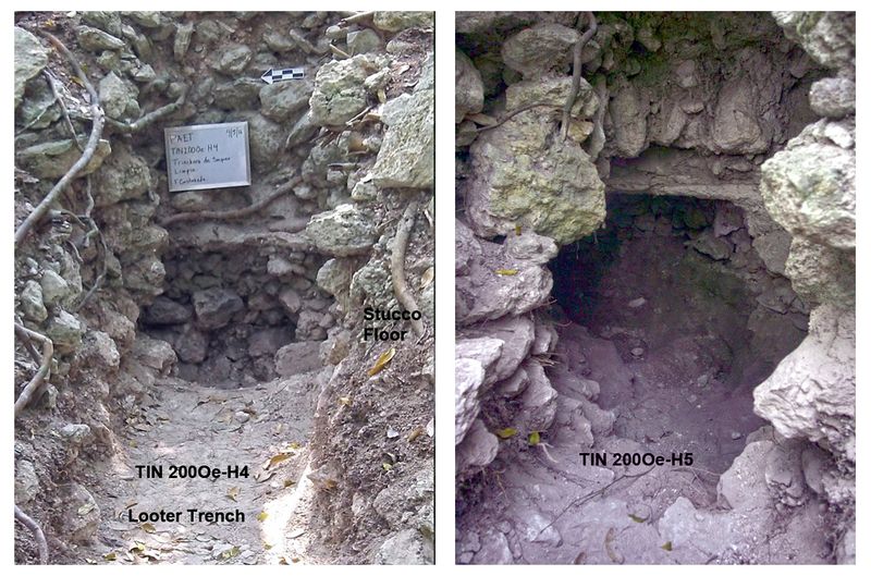 a second floor corresponding to an earlier phase. Preliminary
observations suggest the pottery from both construction phases is dated
to the Late Classic Period (c. AD 550‐850).
a second floor corresponding to an earlier phase. Preliminary
observations suggest the pottery from both construction phases is dated
to the Late Classic Period (c. AD 550‐850). Fig 5. Looters' trenches H4 (left) and H5 (right) showing destroyed stucco floors and other features (photos by F. Castaneda, ETAP) .
Excavations
In 2015 we excavated a deep unit into the frontal range of structure Selepan that provided us with the first understanding of the chronological sequence of the building (Castañeda 2016) . In 2016 a new unit was laid out just south and adjacent to the previous year’s excavation (fig.4). The wall thus exposed shares similar characteristics and construction technique with the wall sections seen inside the looters’ trenches, suggesting they are contemporaneous. The excavation also exposed the corresponding plaster floor, which was 0.10 m thick and in medium state of preservation.
As the excavation continued, through the floor, we discovered it was sealing a special context associated with an earlier architectural phase. Two deposits consisted of clusters of broken pottery with lots of ash and carbon that rested on the construction fill, just below the floor. The deposits were along the same north-south axis as the building alignment. On that same line, a similar deposit was found in the 2015 unit directly over an earlier floor a couple of meters below. These deposits suggest that ceremonial activities of some nature involving burning took place on these buildings at different times during its use and construction. Given the context inside the building fill, the two deposits from 2016 appear to have been in relation to the construction itself prior to completion, while the one from 2015 seems to have occurred directly on an earlier structure, maybe before it was buried by the later building.
 AMS dates of carbon samples place the burning activities in the
mid to late 6th century. Because the contextual evidence of the
deposits suggests they occurred at the same time, we propose based on
the AMS results that the activities took place between AD 550 and 610.
This half century falls right in the transition from the Early to Late
Classic Periods. It is a significant development in our understanding
of the construction sequence, as it is the closest evidence for Early
Classic architecture that we have identified at the site so far. It
also indicates that the architectural phase in between the one housing
the deposits and the Late Preclassic staircase buried below is likely
Early Classic.
AMS dates of carbon samples place the burning activities in the
mid to late 6th century. Because the contextual evidence of the
deposits suggests they occurred at the same time, we propose based on
the AMS results that the activities took place between AD 550 and 610.
This half century falls right in the transition from the Early to Late
Classic Periods. It is a significant development in our understanding
of the construction sequence, as it is the closest evidence for Early
Classic architecture that we have identified at the site so far. It
also indicates that the architectural phase in between the one housing
the deposits and the Late Preclassic staircase buried below is likely
Early Classic.The excavation continued with 3 meters of very loose construction fill consisting of large rocks characterized by the lack of mortar. This substantive construction effort appears to have taken place at the very end of the Early Classic and beginning of the Late Classic Periods, based on the pottery found in the fill and the AMS radiocarbon dates.
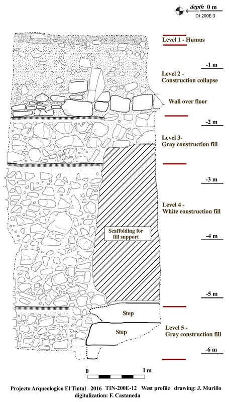
Fig.6: Drawing of the west profile of unit TIN-200E-12 showing the cultural stratigraphy of Structure Selepan.
When the excavation of the unit reached 5.50 m in depth, we reached the first step of a staircase corresponding to a Late Preclassic Period (c. 250 BC – AD 250) building. The adjacent unit excavated in 2015 had reached the same level and exposed a very small section of the steps (Castañeda 2016:52-54). With the new unit we were able to expose three steps of a well-plastered masonry staircase. The southern portion of the staircase had been partially destroyed in antiquity, and based on the evidence of construction fill surrounding it, it seems it was done to make room for a new building. Pottery recovered from the staircase construction fill as well as the architectural style date this earlier structure to the Late Preclassic Period (Fig.10).
 Fig.7: Plan
of the staircase along the central axis of Structure Selepan showing
elevation in meters from datum (drawing by J. Murillo, digitized by
M.J. Acuña).
Fig.7: Plan
of the staircase along the central axis of Structure Selepan showing
elevation in meters from datum (drawing by J. Murillo, digitized by
M.J. Acuña).In 2015 we had determined that the staircase of the final phase was 40 m wide at the base (Castañeda 2016). The new excavations revealed that the staircase reaches the western pyramidal section of Structure Selepan, but the upper section no longer measures 40 m wide. The 40 m-wide staircase likely served to access the rooms located along the top of the anterior platform, identified in the looters’ trenches. Thus far, the evidence suggests that the exposed staircase was a final construction effort that appears to have changed the appearance of the frontal platform of Structure Selepan, as the staircase now passes over the central chambers
To the north of Structure Selepan, the 2015 excavations revealed what appeared to be a later structure wedged into the area between the west (Str. Selepan) and north buildings of Plaza B. Preliminary observations of the pottery collected from the buildings’ surface indicate it corresponds to both the Late and Terminal Classic Periods (c. AD 550 – 900/950). Until now, no Terminal Classic pottery has been found on or in association with Structure Selepan, making its presence on this small architectural addition a significant aspect to explore further. Moreover, there was an elevated concentration of chert material, including nodes, flakes, and micro--‐flakes, suggesting the potential location of a very late lithic workshop.
The 2016 excavations made a great contribution to our understanding of the building within the urban context of the site, allowing us to point out some preliminary results. It is evident that the chronological sequence of occupation for Structure Selepan ranges from at least the Late Preclassic (c. 250 BC – AD 250) through the Late Classic (c. AD 550 –850) Periods. The results of radiocarbon dating pin down construction activity at the very end of the Early Classic and beginning of the Late Classic Periods, providing the first solid evidence for important building events during a very poorly known time period.
El Tintal’s monumentality, urban layout, and location within proximity to El Mirador have always been elements that led scholars to categorize the site as a primarily Preclassic Period (ca. 800 BC – AD 250) city (Hansen 2001, 2012; Mejía et al. 2005). Since 2014, the El Tintal Archaeological Project has found that the Late Classic occupation at the site is substantial throughout the center and periphery of the city. The Early Classic Period (c. AD 250– 550) is still very weakly represented in the archaeological record of the site, but the evidence in Structure Selepan positively points toward important construction at the end of this enigmatic period.
References:
Aguirre Sorondo, Antxon 2001 Las Construcciones de Piedra en Seco, http://www.euskonews.com/0125zbk/gaia12505es.html.
Camacho, Antonio 2007 Construcciones en Piedra Seca. In Revista en Acción, pp. 12-13. vol. 20, Mayo.
Castañeda, Francisco 2016 TIN-200 y 201: Excavaciones en la Acrópolis Central, Complejo Mano de León. In Proyecto Arqueológico El Tintal. Informe No. 2: Resultados de la Segunda Temporada de Campo, 2015, edited by Mary Jane Acuña and Varinia Matute, pp. 43-59. Informe entregado a la Dirección General del Patrimonio Cultural y Natural, Guatemala.
Escobedo, Enrique 2003 Construcciones en Piedra Seca en la Comarca de Mágina. Proceedings of the Actas del I Congreso Nacional de Arquitectura Rural en Piedra Seca:501-508. Zahora.
Hansen, Richard D. 2001 The First Cities: the Beginnings of Urbanization and State Formation in the Maya Lowlands. In Maya: Divine Kings of the Rainforest, edited by Nikolai Grube, pp. 50-65.
Könemann, Munich. 2012 Kingship in the Cradle of Maya Civilization: The Mirador Basin. In Fanning the Flame: Mesoamerican Studies in Honor of H. B. Nicholson, edited by Matthew A. Boxt and Brian D. Dillon, pp. 139-171. University of Colorado Press, Boulder.
Mejía, Héctor E., Gendry Valle, and Enrique Hernández 2005 Tintal, una ciudad arqueológica al sur de El Mirador. In Proyecto Arqueológico Cuenca Mirador. Investigación y Conservación en los Sitios Arqueológicos El Mirador, La Muerta, Xulnal y Tintal. Informe Final de la Temporada 2004., edited by Edgar Suyuc and Richard D. Hansen, pp. 167-206. Informe presentado al Departamento de Monumentos Prehispánicos y Coloniales, Instituto de Antropología e Historia., Guatemala.
Recent Foundation grants: general Archaeology Grants Program w/map
Copyright © 2018 Rust Family Foundation